
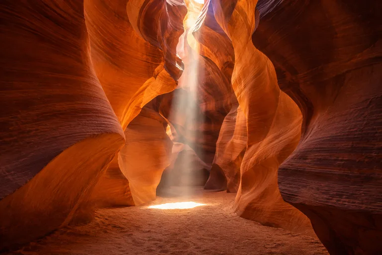
Antelope Canyon and Horseshoe Bend are the two most famous sights around Page, in far northern Arizona, and they pair easily in one day. Antelope Canyon is a sandstone slot canyon on Navajo Nation land, and visits are by guided tour only. Horseshoe Bend is a 1.5-mile round-trip walk to an overlook about 1,000 feet above a bend in the Colorado River. No tour is needed there, just a parking fee paid to the City of Page.
This guide covers how Antelope Canyon tours work, Upper versus Lower Antelope Canyon, the Horseshoe Bend overlook hike and the best time to go. It also lists more things to do in Page, Arizona, with a one-day and a two-day plan. For the rest of the state, see the Arizona travel guide.
Antelope Canyon and Horseshoe Bend at a Glance
| Question | Short answer |
|---|---|
| Where are they? | Both near Page, in far northern Arizona, beside Lake Powell |
| Who manages Antelope Canyon? | Navajo Nation Parks and Recreation, as part of Lake Powell Navajo Tribal Park |
| Can you visit on your own? | Antelope Canyon: no, guides are mandatory. Horseshoe Bend: yes |
| Who manages Horseshoe Bend? | The overlook is in Glen Canyon National Recreation Area; the City of Page runs the parking lot |
| Horseshoe Bend hike | 1.5 miles round trip on a hardened path, about 20 minutes each way |
| Fees | Antelope Canyon: Navajo Nation Parks entry fee plus the tour price. Horseshoe Bend: parking fee per vehicle |
| National park passes | Not accepted at the Horseshoe Bend lot |
| Dogs | Prohibited at Antelope Canyon; leashed dogs allowed at Horseshoe Bend |
| Time zone | Page keeps Mountain Standard Time all year |
Antelope Canyon vs Horseshoe Bend: Side by Side
The two sights could not be more different. One is a narrow, shaded passage seen with a guide. The other is an open walk to a cliff edge at any hour of daylight. Here is how they compare:
| Antelope Canyon | Horseshoe Bend | |
|---|---|---|
| What it is | A slot canyon carved in sandstone | A 270-degree bend in the Colorado River, seen from above |
| Land | Navajo Nation (Lake Powell Navajo Tribal Park) | Glen Canyon National Recreation Area, with a City of Page parking lot |
| Access | Guided tour only, with an authorized company | Walk without a guide from the parking lot |
| Time needed | About 1 to 2 hours for a standard tour, plus check-in | About 20 minutes each way, plus time at the overlook |
| Booking | Reserve ahead; tours often sell out in peak season | No booking; open sunrise to sunset |
| Shade | Shaded inside the canyon | Very little; two shade structures on the trail, none at the overlook |
| Best for | Photographers, families, anyone who wants a guided visit | Big views, sunset, a short walk with a stroller or wheelchair |
Travelers with time for only one should think about who is in the group. Horseshoe Bend costs far less, takes about an hour and works for nearly everyone. Antelope Canyon costs more and needs a booking, but a slot canyon is a rare sight. Most visitors with a full day in Page do both.
Antelope Canyon: Navajo Land and Guided Tours Only
Antelope Canyon is on Navajo Nation land, inside Lake Powell Navajo Tribal Park. Navajo Nation Parks and Recreation manages it. Its rule is clear: "Tour Guides are mandatory to all Antelope Canyon locations." There is no self-guided entry, and every visit starts with an authorized tour company.
The canyon has Navajo names. Navajo Nation Parks gives Upper Antelope Canyon's name as Tse'bighanilini, "the place where water runs through rocks." Lower Antelope Canyon is Hasdez' twazi'. Visitors are guests on Navajo land and follow Navajo Nation rules.
Fees
Navajo Nation Parks charges an entry fee of $15 per person, per location, per day. Guided tours cost extra and are paid to the tour company. Ask whether a quoted tour price includes the park fee. Prices change, so check with the company when booking.
Rules and Closures
- No dogs. "Dogs are Prohibited at all Navajo Tribal Park locations."
- No alcohol. Alcohol is strictly prohibited on the Navajo Nation.
- Holiday closures: Navajo Nation Parks lists closures on Thanksgiving Day, Navajo Nation Family Day (the day after Thanksgiving), Christmas Day and New Year's Day.
- Weather: the park warns that closures are possible because of bad weather.
- Time limit: Upper Antelope Canyon visits have a two-hour limit.
- No photo permits: the park is not accepting photography or filming applications for Upper or Lower Antelope Canyon.
- Leave it as it is: park rules say not to disturb or remove animals, plants, rocks or artifacts.
- At your own risk: the park reminds visitors to stay aware of their surroundings.
Contact: Lake Powell Navajo Tribal Park, near Page (no street address is published; the park lists GPS 36.89755, -111.36576) | 928-645-0268 | navajonationparks.org
Upper vs Lower Antelope Canyon
Antelope Canyon has two main sections, and each is toured by different companies. Upper Antelope Canyon is the easier walk. Lower Antelope Canyon is the more adventurous one.
| Upper Antelope Canyon | Lower Antelope Canyon | |
|---|---|---|
| Where | About three miles east of Page, by Arizona Highway 98 | About four miles east of Page, off Navajo Road 22B |
| Shape | A wider floor that is easier to move through | Narrow, with stairs |
| Stairs and ladders | None inside the canyon, per one Upper company; a hill and stairs or ramps on the walk outside | Stairs and some ladder climbing |
| Light beams | On clear, sunny days from April through September, per one Upper company | Not the main draw |
| Who it suits | Families and most visitors, though not wheelchair accessible | Active visitors comfortable in tight spaces |
| Park Service rating | Easy | Easy to moderate |
Upper Antelope Canyon
Antelope Canyon Tours, one authorized Upper company, starts its tours at its office in Page. Guests ride to the canyon in its trucks. The company describes a total walk of about 1,200 meters. About 400 meters are inside the canyon on level sand, with no ladders or stairs. The walk back to the trucks is about 800 meters and includes a hill with stairs or ramps.
The company warns that the walk can be hard for anyone with a recent knee or hip surgery. It says the tour is not accessible friendly and that strollers do not work in the soft sand.
The light beams are Upper's best-known sight. The same company says they show on clear, sunny days from April through September. It points to its 11:20 AM tour as the one to book for them.
Lower Antelope Canyon
The National Park Service lists Lower Antelope Canyon as an easy to moderate walk of 30 minutes to an hour. It describes the canyon as narrow, with stairs. One Lower company describes the floor as mostly flat with some ladder climbing. It asks guests with mobility concerns to say so when they book.
Lower is the pick for visitors who like a little scrambling and do not mind close walls. Anyone who dislikes tight spaces will be happier in Upper.
Antelope Canyon Tours: How to Book
Only authorized companies may guide Antelope Canyon tours. Navajo Nation Parks keeps the full list on its Antelope Canyon tour operators page. Book from that list, or confirm that a company is on it, before paying.
The City of Page tourism site says tours can sell out weeks ahead. It recommends booking at least one month in advance. If Upper and Lower are full, it points to nearby slot canyons on the same drainage that offer similar views.
Two authorized companies with verified contact details are listed below, one for each main section. They are examples, not endorsements, and other authorized companies run tours too.
Upper Antelope Canyon: Antelope Canyon Tours
This company runs a guided Upper Antelope Canyon sightseeing tour of about an hour and 45 minutes, start to finish. Tours meet and leave from its office on Lake Powell Boulevard in Page. It says its tours always run on Arizona time, the same as Phoenix, with no daylight saving.
- Arrive early: the company asks guests to arrive at least 30 minutes before the tour.
- Clear bags only: only transparent bags are allowed; water and medication may come along.
- No tripods: tripods and monopods are not allowed on the sightseeing tour. Photos are handheld only.
- Cancellations: it lists a full refund for cancellations 48 or more hours ahead. Bookings made inside that window are final.
- No shuttle: guests drive themselves to Page and leave the car at the office.
Visit: Antelope Canyon Tours, 22 South Lake Powell Boulevard, Page, AZ 86040 | 928-645-9102 | antelopecanyon.com
Lower Antelope Canyon: Ken's Tours
Ken's Tours, on Indian Route 222 outside Page, runs Lower Antelope Canyon tours. Its general tour lasts about an hour. A deluxe tour runs 75 to 90 minutes, and longer packages are offered. Its clock is set to Mountain Standard Time. The company says tours often sell out in peak season, March through November, and recommends booking ahead.
Visit: Ken's Tours, Indian Route 222, Page, AZ 86040 | 928-645-6997 | lowerantelope.com
Other Slot Canyons in the Tribal Park
Lake Powell Navajo Tribal Park includes more slot canyons beyond Upper and Lower. Each is also guided only, and each is booked through the company Navajo Nation Parks names for it.
- Antelope Canyon X: two slot canyons with a short walk between them.
- Cardiac Canyon: about 2,600 feet long with walls up to 350 feet. The park calls it strenuous and best for intermediate to advanced hikers.
- Upper East Waterholes: guided tours only, booked through the one company the park names.
A Note on Time Zones
Time zones can be confusing here. The City of Page tourism site says Page is on Mountain Standard Time all year, because Arizona does not observe daylight saving time. It warns that phones may switch zones on their own near Utah and the Navajo Nation. Its advice is to set devices to Phoenix time.
Both companies above list their tours on Mountain Standard Time. Go by the time on the booking, and confirm it with the tour company the day before.
Horseshoe Bend Overlook Hike
The Horseshoe Bend overlook hike is short, but the view is huge. The National Park Service describes a horseshoe-shaped curve of about 270 degrees in the Colorado River, roughly 1,000 feet deep. The City of Page counted more than 1,422,000 visitors there in 2023.
How the Bend Formed
The Park Service explains the shape in three steps:
- The river once wandered across a flat plain in wide loops.
- Around 5 million years ago, the Colorado Plateau rose and trapped the river in its bed.
- Over time, the river cut straight down through the sandstone and kept its looping course.
Where It Is
The parking lot and trailhead are off US Highway 89 between mile markers 544 and 545. That is about 5 miles south of the Carl Hayden Visitor Center at Glen Canyon Dam. From Page, the City of Page says to head southeast on Highway 89 for about 5 miles to the marked turnoff. Do not park on the highway; the city says those cars are ticketed and towed. Drop-offs and pickups along the highway are banned too.
The Trail
- Length: 1.5 miles round trip on a hardened path.
- Climb: 137 feet, per the City of Page.
- Time: about 20 minutes each way, per the City of Page.
- Access: the Park Service says the trail meets federal accessibility rules. The city welcomes wheelchairs, strollers and leashed dogs.
- Shade: two shade structures on the trail, none at the overlook.
- Water and toilets: none on the trail. Use the restrooms in the parking lot first.
- Railings: at the overlook's viewing platform only, not along the trail.
Safety at the Edge
The rim is exposed, and the city warns that sandstone edges can be unstable. Stay inside the fenced area and keep children close. In summer, temperatures can pass 100 degrees, so carry water and avoid the hottest part of the day. The Park Service adds that the ground in full sun is hotter than the air. Drones are not allowed, and neither are bikes, skateboards or motorized vehicles on the trail. For an emergency, call 911.
Horseshoe Bend Parking Fees
The parking lot is on City of Page land, and the city charges for parking. In November 2026 its site listed these rates. Fees change, so check the official site.
| Vehicle | Parking fee |
|---|---|
| Motorcycle | $5 |
| Passenger vehicle (car, truck or RV) | $10 |
| Van or bus, up to 14 people | $35 |
| Van or bus, 15 to 35 people | $70 |
| Bus, over 35 people | $140 |
The city accepts cash and physical cards, but not tap-to-pay. It may take cash only at rare busy times. It offers no discounts or refunds. National park and America the Beautiful passes are not accepted. The lot is open from sunrise to sunset, and the city notes that times may vary.
Visit: Horseshoe Bend (City of Page parking lot), off US Highway 89 between mile markers 544 and 545, south of Page, AZ | 928-645-4271 | horseshoebend.co
Trail rules on the federal side are on the Park Service Horseshoe Bend page.
Best Time to Visit Antelope Canyon and Horseshoe Bend
Both sights are open most of the year, but the season changes the trip. Spring and fall bring the easiest weather. Summer brings the light beams and the heat. Here is what the official sources and the tour companies say:
| Season | Weather, per the Park Service | Antelope Canyon | Horseshoe Bend |
|---|---|---|---|
| Spring | Variable, with long windy spells | Peak season begins in March; light beams start in April in Upper | A good time for the walk before the summer heat |
| Summer | Extremely hot, with little or no shade | Light beam season; busiest tours, so book well ahead | Can pass 100 degrees; walk early or late |
| Fall | Usually pleasant and mild | Beams last through September; peak season runs through November | Cooler walks than in summer |
| Winter | Moderately cold; nights often below freezing | Outside peak season; closed on major Navajo Nation holidays | Open sunrise to sunset; dress in layers |
Summer and fall storms also matter. The Park Service warns that heavy rain and flash flooding are possible around Glen Canyon during the monsoon. Navajo Nation Parks says Antelope Canyon can close for bad weather. If a tour is cancelled for weather, follow the company's refund rules.
Best Time of Day
- Antelope Canyon: late morning in spring and summer for a chance at light beams in Upper. Other tour times are often easier to book.
- Horseshoe Bend: early morning or the hour before sunset in summer, when the trail is cooler. The lot closes at sunset, so allow time for the walk back.
Things to Do in Page, Arizona
Page sits beside Lake Powell and Glen Canyon National Recreation Area, 10 miles south of the Utah border. That makes it a base for far more than two famous stops. Here are the best things to do in Page, Arizona, beyond the canyon and the overlook.
Lake Powell
The Park Service calls Lake Powell a top spot for boating, from houseboats to small fishing boats. Visitors also kayak on the lake and swim in its clear water on hot days. The Bureau of Reclamation gives the lake's length as 186 miles when full, with 1,960 miles of shoreline. Lake levels are changing, so check the park's alerts before planning a boat day.
The Wahweap area is 8 miles from Page, and Antelope Point is 9 miles. Glen Canyon National Recreation Area charges its own entrance fee at those stations. The park's site listed $30 per passenger vehicle for a week in November 2026, paid by card only. National park passes do work there. Check the official site for current fees.
Glen Canyon Dam and the Carl Hayden Visitor Center
Glen Canyon Dam holds back Lake Powell at the edge of town. The Bureau of Reclamation lists its height as 710 feet above bedrock, just 16 feet shorter than Hoover Dam. It was built from 1957 to 1964. The Carl Hayden Visitor Center sits beside the dam, 700 feet above the Colorado River, with a bookstore and a theater. For hours and any tours, check the official site.
Visit: Carl Hayden Visitor Center, US Highway 89 at Glen Canyon Dam, Page, AZ 86040 | 928-608-6072 | nps.gov/glca
Short Hikes Near Town
The Park Service lists several short walks near Page. It notes that Glen Canyon has few maintained trails, so hikers go at their own risk.
- Hanging Gardens: 1.5 miles round trip to a seep spring with lush plants. The trailhead is a quarter mile east of Glen Canyon Bridge.
- Dam Overlook: 940 feet round trip down uneven rock steps to a view of the dam and the river.
- Beehives: an easy wander over slickrock and sand near the Wahweap South Entrance road.
- The Chains: slickrock and sand just east of the dam, with canyon and dam views.
Smooth-Water Rafting to Lees Ferry
Half-day and full-day smooth-water raft trips float the Colorado River from Glen Canyon Dam to Lees Ferry. As the name says, these trips stay on calm water, so they suit families who want to see the river up close. Check who runs them, and the current schedule, before building a day around one.
Lees Ferry and Navajo Bridge
Lees Ferry is 42 miles from Page by Highway 89 south and Highway 89A west. It is the only place in Glen Canyon where visitors can drive to the Colorado River. A ferry crossed here from 1872 until 1928. The Park Service lists these things to see:
- Lonely Dell Ranch: a self-guided walk of about a mile round trip past an orchard, cabins and a cemetery.
- The River Trail: stone buildings, a steam boiler and a sunken paddlewheel steamboat left from a 1910 gold venture.
- Trout fishing: the cold, clear river below the dam is known for trout.
- Navajo Bridge: the historic bridge opened in 1929 and stands 467 feet above the river. It is now a footbridge beside the modern road bridge.
The Navajo Bridge Interpretive Center sits just before the turnoff to Lees Ferry. Gas, a store and a post office are at Marble Canyon, next to the park entrance.
Rainbow Bridge
Rainbow Bridge National Monument protects one of the world's largest natural bridges. Close to 100,000 people make the trip each year, and most arrive by boat across Lake Powell. It is 50 miles from Page by water, with no road. The Park Service warns that at current lake levels the courtesy dock does not reach land. Floating restrooms at the dock are the only facilities.
Visit: Glen Canyon National Recreation Area, PO Box 1507, Page, AZ 86040 (park mailing address) | 928-608-6200 | nps.gov/glca
Getting to Page and Getting Around
Page is a driving destination, and a car is the easiest way to link the sights. The City of Page tourism site puts the town about 280 miles north of Phoenix and 270 miles east of Las Vegas.
| From | Distance or route |
|---|---|
| Phoenix | About 280 miles; Interstate 17 north to Flagstaff, then Highway 89 north |
| Las Vegas | About 270 miles |
| Grand Canyon South Rim | Leave by the East Entrance at Desert View, take Highway 64 to Cameron, then Highway 89 north |
| Lees Ferry | 42 miles; Highway 89A east, then Highway 89 north |
| Utah border | 10 miles north of Page |
- By air: Page has a small airport, code PGA. The Park Service says it has commercial airline service and rental cars.
- Without a car: the Park Service notes a local public bus in the Page, Wahweap and Antelope Point areas. Antelope Canyon Tours offers no shuttle, so guests still need a way to its office.
- Visitor information: the Page Lake Powell Hub downtown has maps and the city's visitor guide.
Visit: The Page Lake Powell Hub, 48 South Lake Powell Boulevard, Page, AZ | 928-608-5749 | visitpageaz.com
Distances in this corner of Arizona are long, and services can be far apart. Check a map app for current drive times, and fill the tank in Page before side trips.
Where to Stay
Most visitors stay in Page itself, which puts both sights within a short drive. One night is enough for the two main stops. Two nights leave room for the lake or Lees Ferry. The city's tourism site lists hotels, rentals and campgrounds. Book early for spring through fall, when tours sell out and rooms follow.
Antelope Canyon and Horseshoe Bend Itineraries
One Day in Page
- Morning: check in 30 minutes early for an Antelope Canyon tour. Choose a late morning Upper tour in spring or summer for a chance at light beams.
- Lunch: back in Page.
- Afternoon: a swim or paddle on Lake Powell, or a stop at the Carl Hayden Visitor Center at Glen Canyon Dam.
- Evening: walk to Horseshoe Bend for the hour before sunset, then walk back before the lot closes.
Two Days in Page
- Day 1: follow the one-day plan above.
- Day 2, morning: the Hanging Gardens walk, or a half-day smooth-water raft trip from Glen Canyon Dam.
- Day 2, afternoon: drive to Lees Ferry. Walk Lonely Dell Ranch, cross Navajo Bridge on foot and watch river trips launch.
A Summer Plan That Beats the Heat
- Sunrise: Horseshoe Bend, when the lot opens and the trail is coolest.
- Late morning: an Upper Antelope Canyon tour, in the shade of the canyon walls.
- Afternoon: Lake Powell for a swim, or indoors at the visitor center.
Add Page to a Grand Canyon Trip
Page fits neatly after a South Rim visit. Drive east along the rim to Desert View, leave by the East Entrance and head north to Page. From Page, Lees Ferry and Navajo Bridge sit on the road toward the North Rim, 85 miles past Lees Ferry.
Hidden Gems Near Page
Most visitors see the two famous stops and move on. These quieter spots reward an extra half day:
- Antelope Canyon X: two slot canyons joined by a short walk, with guided tours only.
- Lower East Waterholes: just off Highway 89 at milepost 542, open with a Navajo backcountry permit.
- Cardiac Canyon: a long, deep slot for fit, experienced hikers on a guided tour.
- Hanging Gardens: a green seep spring in bare slickrock, minutes from the dam.
- Toadstool Trail: 1.5 miles round trip to a garden of balanced rocks, north of the dam on Highway 89 just past mile marker 19.
- Cathedral Wash: a 3-mile round trip down a rocky wash to the Colorado River, on the Lees Ferry road. Skip it when rain is in the forecast.
- Lonely Dell Ranch: orchard, cabins and a pioneer cemetery near Lees Ferry.
- The river from water level: a smooth-water float below Glen Canyon Dam shows the canyon from the bottom up.
Insider Tips for Antelope Canyon and Horseshoe Bend
- Book Antelope Canyon first. Tour times are fixed, so plan Horseshoe Bend and the lake around the tour.
- Book a month ahead for spring through fall, as the city's tourism site advises.
- Check the operator list. Make sure the company is on the Navajo Nation Parks list before paying.
- Pack a clear bag. At least one Upper company allows only transparent bags.
- Leave the tripod in the car for standard sightseeing tours.
- Set the phone to Phoenix time and go by the booking time.
- Bring a physical card and some cash for Horseshoe Bend parking, since tap-to-pay is not taken.
- Carry water to the overlook. There is none on the trail and almost no shade. The city suggests at least a liter per person outdoors.
- Wear closed-toe shoes. Sand and slickrock are easier in them, and the city recommends them all year.
- Leave dogs with a sitter on tour day, since dogs are not allowed at any Navajo Tribal Park.
- Plan around the holidays. Antelope Canyon closes on Thanksgiving, the day after, Christmas and New Year's Day.
Frequently Asked Questions About Antelope Canyon and Horseshoe Bend
Can you visit Antelope Canyon without a tour?
No. Antelope Canyon is on Navajo Nation land, and Navajo Nation Parks and Recreation says tour guides are mandatory at all Antelope Canyon locations. Book with an authorized tour company. The tour price and the Navajo Nation Parks entry fee are separate charges.
Is Upper or Lower Antelope Canyon better?
Upper Antelope Canyon is wider and easier to walk, and one Upper tour company says light beams appear on clear days from April through September. Lower Antelope Canyon is narrower, with stairs and some ladders, so it suits active visitors who are comfortable in tight spaces.
How long is the Horseshoe Bend overlook hike?
The trail is 1.5 miles round trip on a hardened path, and the City of Page says it takes about 20 minutes each way. There are two shade structures on the trail, none at the overlook, and no water or toilets past the parking lot.
How much does it cost to park at Horseshoe Bend?
The City of Page charges for parking at the Horseshoe Bend trailhead, by vehicle type. Its site listed $10 for a passenger vehicle and $5 for a motorcycle in November 2026. National park and America the Beautiful passes are not accepted. Check the official site for current fees.
Can you see Antelope Canyon and Horseshoe Bend in one day?
Yes. Both are near Page. Book an Antelope Canyon tour first, since tour times are fixed, then fit the Horseshoe Bend walk around it. Avoid the hottest part of a summer day at Horseshoe Bend, where there is very little shade.
Do national park passes work at Antelope Canyon or Horseshoe Bend?
Not for these two stops. The Horseshoe Bend lot belongs to the City of Page, which does not accept national park or America the Beautiful passes. Antelope Canyon is a Navajo Tribal Park with its own entry fee plus the cost of a guided tour.
When can you see light beams in Antelope Canyon?
Antelope Canyon Tours, an authorized Upper Antelope Canyon company, says the beams appear on clear, sunny days from April through September. It points to its 11:20 AM tour as the one to book for them. Reserve early for that time.
Are dogs allowed at Antelope Canyon and Horseshoe Bend?
Dogs are prohibited at all Navajo Tribal Park locations, including Antelope Canyon. Leashed dogs are allowed on the Horseshoe Bend trail. Never leave a pet in a parked car, and watch for hot ground that can burn paws.
What time zone is Page, Arizona, in?
The City of Page tourism site says Page is on Mountain Standard Time all year, because Arizona does not observe daylight saving time. Phones can switch zones near Utah and the Navajo Nation. The site suggests setting devices to Phoenix time. Go by the time on the tour booking.
What are the best things to do in Page, Arizona?
Beyond Antelope Canyon and Horseshoe Bend, Page is the base for Lake Powell boating, kayaking and swimming. Other favorites are the Glen Canyon Dam visitor center, short slickrock hikes, and smooth-water rafting to Lees Ferry. Historic Lees Ferry and Navajo Bridge are 42 miles away.
Planning your next U.S. getaway? Explore more destination guides, road trips, and travel tips at Vacation Getaways US. Have a question or a spot we should cover? Email us at [email protected].