
How To Plan An Amazing Weekend Getaway: Tips For Your Next Trip
May 21, 2021
Simple steps for planning a short trip, from picking dates to booking a place to stay.
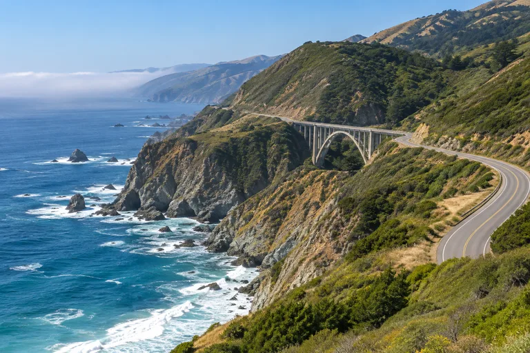
A Big Sur road trip follows a roughly 90 mile stretch of Highway 1 on California's Central Coast, from Carmel-by-the-Sea in the north to Hearst Castle near San Simeon in the south. It can be driven in one long day, but two or three days give time for the redwoods, the state parks, a waterfall that drops to the sea and a castle tour. The one rule that matters most: check that the road is open before leaving, because this highway closes for slides and storms.
This guide lists the best Big Sur stops in order with their distance from Carmel, lays out a Pacific Coast Highway itinerary for three days, and stretches it into a longer drive from San Francisco to Los Angeles. It is one of the classic trips in the California travel guide, and it suits couples, families and solo travelers who like a slow road with a view around every bend.
| Question | Short answer |
|---|---|
| Where is Big Sur? | The coast between Carmel-by-the-Sea and Hearst Castle, on Highway 1 |
| How long is it? | Roughly 90 miles, by Visit California's count |
| How much time? | One long day to drive it. Two or three days to enjoy it. |
| Best direction? | North to south, so the ocean is on the driver's side of the road |
| Is the road open? | It changes. Check Caltrans QuickMap on the day of travel. |
| Typical state park fee | $10 per vehicle for day use, as listed in November 2026 |
| Where to sleep? | Monterey or Carmel in the north, Big Sur itself, or San Simeon and Cambria in the south |
Check on the day of travel, every time. Highway 1 through Big Sur is cut into steep slopes above the ocean, and slides, storms and fires close parts of it often. A closure in the middle turns the through drive into two out-and-back trips, one from each end.
The recent record shows why the check matters:
That last closure was in place on the day this guide was written, and it may be long over by the time of a trip. Use these official tools:
A closure does not have to cancel the trip. From the north, the stops between Carmel and the closure point make a round trip from Monterey when that part of the road is open. From the south, San Simeon, Hearst Castle, the elephant seals and Ragged Point make a full day. Travelers who need to get between the two ends use US 101 inland. Book lodging that can be changed, and decide the route the night before.
North to south is the favorite direction for a Big Sur road trip. Southbound traffic uses the ocean-side lane, so the views sit on the driver's right and most turnouts can be reached without crossing oncoming traffic. Travelers who start in Los Angeles can drive it south to north and lose very little.
| Time | What fits | Best for |
|---|---|---|
| One day | The drive itself, Bixby Bridge, one park stop and McWay Falls | Travelers passing through |
| Two days | Point Lobos, the redwoods, Pfeiffer Beach, McWay Falls and a night in Big Sur or Carmel | A weekend from the Bay Area |
| Three days | All of the above plus Monterey, Hearst Castle and the elephant seals | First visits |
| Four to five days | The full coast from San Francisco to Los Angeles | A one-way trip with a rental car |
Spring and fall are the easiest seasons for most travelers, with fewer cars than summer and less storm risk than winter. Each season has a real trade-off on this coast.
| Season | What to expect | Watch for |
|---|---|---|
| Winter | Quiet roads. Elephant seal activity peaks in late January. | Storm closures, debris flows, park closures on short notice |
| Spring | Wet-season closures start to lift. Another elephant seal peak in April. | Sycamore Canyon Road to Pfeiffer Beach may close after rain |
| Summer | Long days, with seasonal trail camps open | Full parking lots on weekends and holidays, and wildfires, as in August 2026 |
| Fall | Fewer visitors. A third elephant seal peak in October. | Some trail camps and footbridges close for the wet season from late October |
Two small examples show how the seasons shape a visit. The Forest Service says the 65 space lot at Pfeiffer Beach is usually full on summer and holiday weekends. At Andrew Molera State Park, the seasonal footbridge over the Big Sur River is taken out in late October, and the trail camp closes from November 1 until about May 1 because it sits in a flood zone.
The north end of the trip deserves its own day. Monterey and Carmel sit at the top of the Big Sur coast, and they are the place to fill the tank and stock up before the road turns wild.
Travelers with only two days can skip 17-Mile Drive and spend the time at Point Lobos, which shows the same kind of coast on foot.
The table lists the main Big Sur stops in driving order from Carmel. Distances come from California State Parks and the Los Padres National Forest. Day-use fees are the ones listed in November 2026 and can change, so check each official page.
| Stop | Distance from Carmel | Why stop | Day-use fee |
|---|---|---|---|
| Point Lobos State Natural Reserve | 3 miles south | Coves, sea otters, harbor seals, short trails | $10 per vehicle |
| Garrapata State Park | 6.7 miles south of Rio Road | Headlands and two miles of beach | None listed |
| Bixby Bridge | Between Garrapata and Point Sur | The most famous bridge on the coast | None |
| Point Sur State Historic Park | 19 miles south | An 1889 lighthouse on a 361 foot rock, by guided tour | Tour fee |
| Andrew Molera State Park | 20 miles south | 15 miles of trails, river and beach | $10 per vehicle |
| Pfeiffer Big Sur State Park | 26 miles south | Coast redwoods, the Big Sur River, lodge and campground | $10 per vehicle |
| Pfeiffer Beach | Off Sycamore Canyon Road, just south of the park | Keyhole Rock, picnic tables and beachcombing | $15 per vehicle |
| Julia Pfeiffer Burns State Park | 37 miles south | McWay Falls, an 80 foot waterfall into the ocean | $10 per vehicle |
| Limekiln State Park | 56 miles south | A creek, a beach, trails and a campground in one park | $10 per vehicle, cash only |
| Sand Dollar Beach | 60 miles south | The largest public beach on the southern Big Sur coast | $10 per vehicle |
| Ragged Point | The southern gateway to Big Sur | Lookouts, an inn, food and gas | None |
| Piedras Blancas elephant seal viewing area | North of San Simeon | Elephant seals on the beach all year | Free |
| Hearst Castle | San Simeon | Guided tours of the Hearst estate | Tour ticket |
Point Lobos is the first big stop, three miles south of Carmel. Its trails lead to coves such as Whalers Cove, and the water holds harbor seals and sea otters. Day use runs from 8 am to 5 pm with last entry at 4:30 pm. Vehicles longer than 21 feet may not enter, dogs are not allowed anywhere in the reserve, and the Whalers Cabin Museum opens from 9 am to 5 pm as staffing allows. The reserve closes in high winds and heavy surf, as it did on November 18, 2026.
Contact: Point Lobos State Natural Reserve, Route 1 Box 62, Carmel, CA 93923. Phone: 831-624-4909. Web: parks.ca.gov.
Garrapata State Park starts 6.7 miles south of Rio Road in Carmel and is entered through numbered gates along the highway. It holds two miles of beachfront and the headlands of Soberanes Point. The Soberanes Canyon Trail, across from Gate 8, runs about 1.25 miles to the back of the canyon. The park is day use only, from 8 am to sunset. State Parks asks visitors to take extreme care when parking and crossing Highway 1 here.
Bixby Bridge is the picture most people have in mind when they think of this drive, and it draws a crowd to match. Visit California says stopping or parking is no longer allowed at either end of the bridge, and that crawling across or making a U-turn is prohibited. Obey the signs posted on the day. The safest plan is to let a passenger take the photo and keep the car moving.
The Point Sur lighthouse stands on a 361 foot volcanic rock just off the shore. It was first lit on August 1, 1889, and keepers and their families lived there until the light was automated in 1974. The park is closed to the public except by guided tour. In November 2026 the three hour lightstation tours were listed for Saturdays, Sundays and Wednesdays, first come, first served, with no reservations. Check the official page for the current days, times and prices.
Andrew Molera State Park, 20 miles south of Carmel, is the place to stretch legs. It has 15 miles of trails across meadows, bluffs and the mouth of the Big Sur River. The park is open from 8 am until sunset. In the wet season the footbridge on the Creamery Meadow Trail is removed, so ask at the entrance which trails are reachable.
Pfeiffer Big Sur State Park, 26 miles south of Carmel, is the redwood stop. Coast redwoods line the Big Sur River, and the park holds what State Parks calls Big Sur's largest campground, plus the Big Sur Lodge. The campground, the lodge and the Redwood Grove Boardwalk reopened on October 16, 2026 after the fire. The Valley View and Pfeiffer Falls trails were still closed until further notice in November 2026 for recovery work in burned areas.
Pfeiffer Beach belongs to the Los Padres National Forest, not the state park of nearly the same name. The turn onto Sycamore Canyon Road is hard to see and sits between the Big Sur Ranger Station and the post office. The road is a single lane, 2.2 miles long, and walking in is not allowed under a rule in force until January 29, 2027. The lot holds 65 vehicles. Keyhole Rock is the landmark. There is no drinking water, and swimming is hazardous because of cold water, rocks and rip currents.
McWay Falls is the postcard of the southern coast. The 80 foot waterfall drops from granite cliffs into the ocean in Julia Pfeiffer Burns State Park, 37 miles south of Carmel and 12 miles south of Pfeiffer Big Sur State Park. It is viewed from above. State Parks is blunt about the rest: there is no beach or ocean access at McWay Falls, and the cliff areas beyond the fences are off limits. Dogs are not allowed. The park is open from 8 am to sunset when the highway is open, and it was closed with the road on November 18, 2026.
Limekiln State Park sits 56 miles south of Carmel and two miles south of Lucia, at the south end of the bridge over Limekiln Creek. It has a creek, a beach, hiking trails and a campground, and it is named for the limekilns in its history. The kiosk takes cash only. Some trails were closed in November 2026, and the park could not be reached while the highway was shut.
Sand Dollar Beach, 60 miles south of Carmel and 30 miles north of San Simeon, is the largest public beach on the southern Big Sur coast, reached by a short trail and a staircase. The Forest Service listed it as closed after the Timber and Plaskett fires in August 2026, so confirm it has reopened.
Ragged Point is the southern gateway to Big Sur. The Ragged Point Inn has lodging, dining, a gift shop and a gas station, with lookouts facing north and south. A moderately strenuous cliffside trail of about 0.8 miles leads down to a black sand beach.
Farther south, the wildlife takes over. At the Piedras Blancas elephant seal viewing area, visitors watch northern elephant seals from accessible viewing areas, free and with no reservation, all year. State Parks says the largest numbers and the most activity come in late January, April and October. There are no restrooms at the viewing area.
The drive ends at Hearst Castle, the estate designed by architect Julia Morgan for William Randolph Hearst. It is seen by guided tour, with choices that include the Grand Rooms, the Upstairs Suites and the Cottages and Kitchen. Reserve ahead in busy months, and check the official site for tour times and prices.
Contact: Hearst Castle, 750 Hearst Castle Road, San Simeon, CA 93452. Phone: (800) 444-4445. Web: hearstcastle.org.
This Pacific Coast Highway itinerary runs north to south and assumes the road is open the whole way. If it is not, use days one and two as a round trip from Monterey and save day three for a separate visit from the south.
Contact: Monterey Bay Aquarium, 886 Cannery Row, Monterey, CA 93940. Phone: 831-648-4800. Web: montereybayaquarium.org.
Big Sur is the centerpiece of a longer trip. For the PCH from San Francisco to Los Angeles, plan four to five days. As a guide, Visit California's Highway 1 Classic route covers 608 miles between San Diego and San Francisco and suggests four to seven days. Its stops include Pescadero, Monterey, Big Sur, Hearst Castle, San Luis Obispo, the Santa Ynez Valley and Santa Barbara.
| Day | Route | Highlights |
|---|---|---|
| 1 | San Francisco to Monterey | Half Moon Bay, Pigeon Point Light Station, Santa Cruz |
| 2 | Monterey and Carmel | Monterey Bay Aquarium, Carmel-by-the-Sea, Point Lobos |
| 3 | Carmel to San Simeon or Cambria | The Big Sur stops above |
| 4 | San Simeon to San Luis Obispo or Santa Barbara | Hearst Castle, Moonstone Beach in Cambria, Morro Rock |
| 5 | Santa Barbara to Los Angeles | Santa Barbara, then the last stretch of coast into the city |
A few stops outside Big Sur are worth the time:
Travelers who want more coast after this drive can look north to the Oregon Coast road trip guide.
Where to sleep depends on how much driving feels right after dark. This is not a road to drive tired.
Services are thin on this coast, and that is part of its charm. A little planning keeps it from becoming a problem.
These quieter stops get far fewer visitors than Bixby Bridge and McWay Falls.
The Big Sur coast is wild, and the park rules are there for safety. California State Parks gives one warning for the beaches at Garrapata: never turn your back on the ocean.
May 21, 2021
Simple steps for planning a short trip, from picking dates to booking a place to stay.

May 21, 2021
Ways to compare fares and find flight deals before booking a trip to California.

April 28, 2021
A checklist of what to pack for a two or three day trip in any season.
The Big Sur coast is a roughly 90 mile stretch of Highway 1 between Carmel-by-the-Sea and Hearst Castle. It can be driven in one long day with a few stops. Two or three days allow time for a state park hike, the redwoods, a Hearst Castle tour and a relaxed pace.
It changes, so check on the day of travel. Highway 1 reopened at Regent's Slide on January 14, 2026 after a closure that began in February 2024. On November 18, 2026 the highway on the Big Sur coast closed again ahead of a storm because of the threat of debris flows from a burned area. Caltrans QuickMap shows the current status.
Visit California describes Big Sur as the stretch of coast from Carmel-by-the-Sea in the north to Hearst Castle near San Simeon in the south. Most road trips begin in Monterey or Carmel and end in San Simeon or Cambria, or run the other way.
North to south is the favorite. Southbound traffic uses the lane on the ocean side, so the views are on the driver's right and most turnouts can be reached without crossing the road. South to north works just as well when the trip begins in Los Angeles.
The best Big Sur stops from north to south are Point Lobos State Natural Reserve, Garrapata State Park, Bixby Bridge, Andrew Molera State Park, the redwoods of Pfeiffer Big Sur State Park, Pfeiffer Beach, McWay Falls in Julia Pfeiffer Burns State Park, Limekiln State Park, Ragged Point, the elephant seals at Piedras Blancas and Hearst Castle.
Visit California says stopping or parking is no longer allowed at either end of Bixby Bridge, and that drivers should not slow to a crawl or make U-turns there. Follow the signs on the day and enjoy the view from a passenger seat or a legal turnout farther along.
No. California State Parks says there is no beach or ocean access at McWay Falls, and the cliff areas beyond the fences are off limits. The 80 foot waterfall is seen from above in Julia Pfeiffer Burns State Park, 37 miles south of Carmel.
Fill the tank in Monterey or Carmel at the north end, or in Cambria or San Simeon at the south end. Gas stations inside Big Sur are few. The Ragged Point Inn at the south end has a gas station.
Plan four to five days for the Pacific Coast Highway between San Francisco and Los Angeles. Visit California suggests four to seven days for its 608 mile Highway 1 Classic route between San Diego and San Francisco, which covers the same coast and a little more.
Rules vary by park. Dogs are not allowed at Point Lobos State Natural Reserve or Julia Pfeiffer Burns State Park. Garrapata State Park allows leashed dogs only on the beach at Gate 19. Pfeiffer Beach and Sand Dollar Beach allow dogs on a leash no longer than six feet.
Planning your next U.S. getaway? Explore more destination guides, road trips, and travel tips at Vacation Getaways US. Have a question or a spot we should cover? Email us at [email protected].