
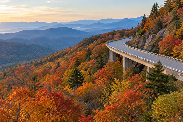
The Blue Ridge Parkway crosses into North Carolina at milepost 216.9. It runs to its southern end at milepost 469, beside Great Smoky Mountains National Park. The best stops include Moses H. Cone Memorial Park, the Linn Cove Viaduct, Linville Falls and Craggy Gardens. Add the Folk Art Center near Asheville, Graveyard Fields and Waterrock Knob. Hurricane Helene closed the whole road in September 2024. On November 18, 2026, the National Park Service listed one Helene section as still closed, plus several high sections closed for weather. This Blue Ridge Parkway North Carolina guide shares exactly what the Park Service says and sends drivers to the official road status page.
First comes the road status on the day this guide was checked. Next are the best stops by milepost, Linville Falls and a fall color guide. Then come the best time to visit, how to reach the Parkway and a three-day drive plan. For the rest of the state, see the North Carolina travel guide.
Blue Ridge Parkway in North Carolina at a Glance
| Question | Short answer (National Park Service) |
|---|---|
| Total length | 469 miles, from Virginia to the edge of Great Smoky Mountains National Park |
| North Carolina section | From the state line at milepost 216.9 to US 441 at milepost 469 |
| Entrance fee | None; camping has fees |
| Speed limit | 45 mph in general, lower in busy areas |
| Tunnels | 26 in all; one in Virginia, the rest in North Carolina, mostly south of Asheville |
| Highest point | Richland Balsam Overlook, milepost 431.4, 6,053 feet |
| Main visitor center | Blue Ridge Parkway Visitor Center, milepost 384, Asheville |
| Road line | 828-348-3400 |
Visit: Blue Ridge Parkway, 199 Hemphill Knob Rd, Asheville, NC 28803 (park mailing address) | 828-348-3400 | nps.gov/blri
Every stop named below inside the Parkway is run by the National Park Service, so the park contact above covers them. Places outside the Parkway, such as Mount Mitchell State Park and Grandfather Mountain, have their own contact lines further down.
Road Status Today: Helene and Weather Closures
The short answer: most of the North Carolina Parkway is open, but one Helene section is still closed. Weather can also close the high country, especially in winter. Closures change during the day, so this section is a snapshot, not a promise.
What Helene Did to the Parkway
The Park Service's recovery page, updated September 15, 2026, gives the scale of the storm. Helene brought up to 30 inches of rain and winds up to 60 mph to parts of the Parkway. At first, 100 percent of the 469-mile route was closed. The park counted 58 catastrophic landslides, and damage was concentrated in North Carolina.
The heaviest damage ran from the Linville Falls area near milepost 317 south to Mount Mitchell State Park near milepost 355. By fall 2025, more than 400 miles were open again. The page also counts 140 miles of reopened trails.
Where Recovery Stands
In an October 5, 2026 news release, the Park Service said access had been restored to 458 of the Parkway's 469 miles. It said the final Helene road repairs, from milepost 344 to 355, are slated for completion and reopening by the end of 2026. The same release said drivers can now travel without a break from the James River in Virginia to Little Switzerland, near milepost 344.
Status on November 18, 2026
The table below copies the North Carolina sections of the Parkway road status page as posted at 10:20 a.m. on November 18, 2026. Short neighboring rows are grouped. "Ungated" is the park's word for sections that are open except in emergency situations.
| Mileposts | Section | Status on November 18, 2026 |
|---|---|---|
| 216.9 to 249.3 | State line to South Laurel Fork Road, including Doughton Park | Open |
| 249.3 to 261.2 | South Laurel Fork Road to NC 16 | Ungated |
| 261.2 to 298.5 | NC 16 past Blowing Rock, Moses Cone Manor and Price Park to Holloway Mountain Road | Open or ungated, with sporadic short single-lane closures for road projects |
| 298.5 to 305.1 | Holloway Mountain Road to US 221 at Beacon Heights, including the Linn Cove Viaduct | Listed as a full closure due to weather |
| 305.1 to 317.5 | Beacon Heights to US 221 at Linville Falls | Open or ungated; Linville Falls Spur Road open; campground and picnic area closed (Helene) |
| 317.5 to 344.2 | US 221 past Little Switzerland and Crabtree Falls to NC 80 | Open or ungated, with sporadic short single-lane closures; Crabtree Falls Campground closed |
| 344.2 to 355.3 | NC 80 to Mount Mitchell State Park | Closed, Helene related; recreation of any kind is not allowed |
| 355.3 to 375.7 | Mount Mitchell State Park, Craggy Gardens and on to Bull Gap | Closed for weather |
| 375.7 to 382.8 | Bull Gap past the Folk Art Center to Highway 70 (Tunnel Road) | Open or ungated |
| 382.8 to 384.1 | Highway 70 (Tunnel Road) to Park Headquarters and Visitor Center | Closed at Tunnel Road; reach headquarters from Highway 74A |
| 384.1 to 405.5 | Park Headquarters past Highway 74 to the NC 151 access road | Open or ungated, with short daytime lane control near Brevard Road |
| 405.5 to 411.9 | Elk Pasture Gap past the Pisgah Store to US 276 | Closed for road maintenance |
| 411.9 to 423.2 | US 276 past Graveyard Fields and Black Balsam to Beech Gap (NC 215) | Open |
| 423.2 to 469.1 | Beech Gap to Balsam Gap, Soco Gap and US 441 | Closed for weather |
The same page listed Bluffs Lodge as closed and the Linn Cove Visitor Center as temporarily closed. Call the road line at 828-348-3400 before any long drive, and check the page again that morning.
How to Drive the Parkway: The Basics
The Parkway is a slow, scenic road, not a shortcut. These rules and facts come from Park Service pages:
- Mileposts count up from Virginia. North Carolina starts at milepost 216.9, Asheville sits near 382 to 384, and the road ends at 469.
- The speed limit is 45 mph. It drops to 35 near busy spots such as Moses Cone Manor, Mount Pisgah and Graveyard Fields. It drops to 25 at the Craggy Gardens Visitor Center area and the Waterrock Knob access road.
- There is no entrance fee. The park says fees are charged for camping.
- Pets are welcome on a short leash. The limit is six feet, and pets must be under physical control.
- Use the overlooks. The park asks drivers who are new to mountain roads to obey the limit and pull into overlooks to let others pass.
- Plan gas and meals in town. The Park Service points travelers to its Directory and Travel Planner for services in nearby communities.
Tunnels and Taller Vehicles
The Park Service counts 26 tunnels on the Parkway. One is in Virginia and the rest are in North Carolina, mostly south of Asheville. Its tunnel heights page lists the lowest edgeline heights near the southern end:
- Big Witch Tunnel, milepost 461.2: 11 feet 7 inches
- Lickstone Ridge Tunnel, milepost 458.8: 11 feet 8 inches
- Bunches Bald Tunnel, milepost 459.3: 12 feet 3 inches
The park's advice is to enter tunnels slowly and with care. RV drivers should check the full tunnel heights table before heading south of Asheville.
Best Blue Ridge Parkway Stops in North Carolina
The best Blue Ridge Parkway stops in North Carolina mix short walks, big views and a few historic sites. The table lists them from north to south, with the milepost the Park Service gives. The last column shows the status of each stop's section on November 18, 2026.
| Milepost | Stop | Why stop | Section status, Nov 18, 2026 |
|---|---|---|---|
| 217.5 | Cumberland Knob | Easy 0.5-mile trail just south of the state line | Open |
| 238 to 241 | Doughton Park | Visitor center and longer day hikes | Open; Bluffs Lodge closed |
| 294 | Moses H. Cone Memorial Park | Flat Top Manor and carriage trails | Open, short lane closures |
| 297 | Julian Price Park | Price Lake, canoeing and a lake loop | Open, short lane closures |
| 304 | Linn Cove Viaduct | The famous bridge around Grandfather Mountain | Full closure due to weather |
| 305.2 | Beacon Heights | A 0.2-mile climb to a view | Open |
| 316.4 | Linville Falls | Upper falls view trail | Spur road open; some trails closed |
| 331 | Museum of North Carolina Minerals | Visitor center near Spruce Pine | Open, short lane closures |
| 339.5 | Crabtree Falls | A 2.5-mile loop to a waterfall | Trail open; some bridge closures |
| 355.3 | Mount Mitchell State Park (via NC 128) | Highest point east of the Mississippi River | Closed |
| 364 | Craggy Gardens | Visitor center and Craggy Pinnacle | Closed for weather |
| 382 | Folk Art Center | Mountain crafts near Asheville | Open |
| 384 | Blue Ridge Parkway Visitor Center | The main visitor center | Reach from Highway 74A |
| 407.6 to 408.8 | Mount Pisgah | Summit trail and campground | Closed for road maintenance |
| 418.8 | Graveyard Fields | Loop trail and two waterfalls | Open |
| 422.4 | Devil's Courthouse | A 0.4-mile climb to a summit view | Open |
| 431.4 | Richland Balsam Overlook | Highest point on the Parkway | Closed for weather |
| 451.2 | Waterrock Knob | Highest visitor center on the Parkway | Closed for weather |
The High Country: Mileposts 216.9 to 305
The northern end of the North Carolina Parkway climbs from the state line toward Blowing Rock and Grandfather Mountain. These are the main stops on the way:
- Cumberland Knob, milepost 217.5: the Cumberland Knob Trail is an easy 0.5-mile walk. The Gully Creek Trail is a strenuous 2-mile loop beside a stream.
- Doughton Park, mileposts 238 to 241: the Park Service lists its visitor center at both 238 and 241 on different pages. The Cedar Ridge Trail runs 4.2 miles, and the Fodder Stack Trail is a 1-mile walk.
- Moses H. Cone Memorial Park, milepost 294: Flat Top Manor sits here near Blowing Rock. The Park Service lists a web of carriage, horse and hiking trails, including an easy 1.7-mile trail to Bass Lake.
- Julian Price Park, milepost 297: the Park Service says visitors can rent canoes or bring their own at Price Lake. The Price Lake Loop Trail runs 2.7 miles.
Linn Cove Viaduct and Grandfather Mountain
The Linn Cove Viaduct at milepost 304 is the Parkway's most famous bridge. The Park Service says it is 1,234 feet long. It was designed to protect the fragile habitat of Grandfather Mountain. The viaduct was finished in 1982 and opened to the public in 1987, completing the 469-mile Parkway.
The 13.5-mile Tanawha Trail links Julian Price Park with Beacon Heights. The park recommends it for views of the viaduct and the mountain. On November 18, 2026, this stretch was listed as a full closure due to weather, and the Linn Cove Visitor Center was temporarily closed.
Grandfather Mountain is a separate, ticketed attraction reached from US 221, which meets the Parkway near milepost 305. It is home to the Mile High Swinging Bridge. Its site says buying advance tickets online is highly recommended.
Visit: Grandfather Mountain, 2050 Blowing Rock Highway, Linville, NC 28646 | 1-800-468-7325 | grandfather.com
Little Switzerland to Mount Mitchell: Mileposts 317 to 355
South of Linville Falls, the Parkway enters the area hit hardest by Helene. Recovery projects from milepost 317.5 to 324.7 and from 333.9 to 340.2 are complete, according to the October 2026 release.
- Museum of North Carolina Minerals, milepost 331: a Park Service visitor center near Spruce Pine.
- Crabtree Falls, milepost 339.5: the loop trail to the falls is 2.5 miles and rated strenuous. The road status page says the trail is open with some walking bridge closures. The picnic area is open, but the campground is closed.
- Mount Mitchell State Park, milepost 355.3: reached by NC 128 from the Parkway. North Carolina State Parks says the mountain, at 6,684 feet, is "the highest point east of the Mississippi River."
On November 18, 2026, the Parkway from NC 80 to Mount Mitchell State Park was closed as a Helene related closure. The state park's own page said it was closed because of incoming severe weather. It also said the gift shop, summit concession stand and restaurant are closed for the 2026 season and are scheduled to open in May 2027.
Visit: Mount Mitchell State Park, 2388 N.C. 128, Burnsville, NC 28714 | 828-867-4000 | ncparks.gov
Craggy Gardens and Asheville: Mileposts 355 to 405
North of Asheville, Craggy Gardens has a visitor center at milepost 364. The Craggy Pinnacle Trail, at 364.2, is a 0.7-mile climb to a panoramic view. The Craggy Gardens Trail at 364.6 begins as a self-guided nature trail. This whole stretch was closed for weather on November 18, 2026.
Closer to the city, the Folk Art Center sits near milepost 382, at the end of the open section from Bull Gap. The Mountains-to-Sea Trail runs from there toward Mount Mitchell. The Blue Ridge Parkway Visitor Center at milepost 384 is the main visitor center, and the Park Service says it is open year-round. It closes on Thanksgiving, December 25 and January 1. While the Tunnel Road side is closed, reach it from Highway 74A.
South of Asheville: Mileposts 405 to 469
The southern Parkway climbs to its highest ground. These stops reward a clear day:
- Mount Pisgah, mileposts 407.6 to 408.8: the Mt. Pisgah Trail climbs 1.3 miles to a summit view, and the campground is at 408.8. This section was closed for road maintenance on November 18, 2026.
- Graveyard Fields, milepost 418.8: a loop trail beside a stream with two waterfalls, covered in more detail under hidden gems below.
- Devil's Courthouse, milepost 422.4: a 0.4-mile trail to a panoramic summit view.
- Richland Balsam Overlook, milepost 431.4: the highest point on the Parkway at 6,053 feet, with red spruce and Fraser fir.
- Waterrock Knob, milepost 451.2: the Park Service says the visitor center sits at 5,820 feet, the highest on the Parkway. It is open seasonally, and the summit trail is 0.6 mile.
Everything south of Beech Gap, milepost 423.2, was closed for weather on November 18, 2026. That stretch includes Richland Balsam and Waterrock Knob, and it runs down to US 441.
Linville Falls
Linville Falls sits at milepost 316.4, a short drive south of Grandfather Mountain. The Park Service says the Linville River drops through two falls, the Upper Falls and the Lower Falls. It is also the stop most changed by Helene, so plan with care.
What Is Open at Linville Falls
The Park Service trail list, updated November 9, 2026, shows this status:
- Linville Falls Trail: open. It is listed at 0.8 mile, moderate, with a view of the upper falls. Access is through the Forest Service lot on Old NC 105.
- Linville Gorge Trail: closed. It is the strenuous route to the lower falls.
- Duggers Creek Trail: closed. It is a short, easy loop to Duggers Falls.
- Linville River Bridge Trail: closed.
- Chestoa View Trail, milepost 320.8: closed. It is an easy 0.6-mile loop to a vista.
The same list warns that open trails may still hold unseen hazards from Helene damage. The road status page on November 18, 2026 showed the Linville Falls Spur Road as open. The campground and picnic area were closed as a Helene related closure. The Park Service's 2025 recovery page said Helene destroyed facilities here, including the visitor center, a picnic area comfort station and parts of the campground.
The Trails When Fully Open
The Park Service's Linville Falls trails page describes the full trail system. It helps to know what the area offers once all routes reopen:
- Erwins View Trail: a moderate 1.6-mile round trip with four overlooks, from the upper falls to a wide gorge view. The Chimney View section is strenuous.
- Linville Gorge Trail: 1.4 miles round trip, strenuous, down through rock cliffs to the bottom of the falls.
- Plunge Basin Trail: 1 mile round trip, strenuous, to a view of the lower falls and the Chimneys.
The park's general Linville Falls page suggests avoiding weekends for a less crowded visit. Waterfall rocks are slippery, so stay on the trail and behind any railings.
Blue Ridge Parkway Fall Colors
Fall color is a favorite reason to drive the Parkway. The Park Service says that fall colors typically develop during mid to late October. Here is how the season plays out, based on the park's fall colors page and FAQ:
- Late September: scattered trees on the highest peaks can show color, since those ridges have a climate like New England's.
- October: most trees change. Color starts on the highest peaks and moves down the mountainsides as the month goes on.
- Late October: lower slopes and valleys catch up.
- No fixed date: the park says exact peak dates at specific places cannot be predicted in advance.
What Makes a Good Color Year
The Park Service says about 100 species of native trees grow in the southern Appalachians. Most drop their leaves, and each species turns at its own time. That is why the season runs long. The best displays come when days are bright, sunny and cool and nights are cool but not freezing, with good rainfall. Wet, cloudy, warm weather or very cold early fall days tend to dull the color.
Where to See Fall Color
Because color starts high, the high stops tend to turn first. Graveyard Fields, Devil's Courthouse, Richland Balsam and Waterrock Knob sit on the highest stretch south of Asheville. In the north, Moses Cone, Price Lake and the Linn Cove Viaduct frame color around Grandfather Mountain. Do not skip the fall wildflowers either; the park points to purple asters along roads and trails.
The Park Service says Graveyard Fields parking fills up on weekends and busy days. It also warns that cars parked in restricted spots there have rolled down a steep bank. Park only where the roadside signs allow.
Best Time to Visit the Blue Ridge Parkway
The best time to visit for most families and couples is late spring through October. Fall brings color and crowds, while winter brings ice, snow and closures. This table sums up what the official sources say:
| Season | What to expect (official sources) | Good to know |
|---|---|---|
| Spring | Most visitor contact stations are seasonal, typically open from May through October | Mount Mitchell State Park keeps longer hours from May |
| Summer | Facilities are open and campgrounds run; Graveyard Fields parking fills on weekends | Go early in the day for parking at popular trailheads |
| Fall | Scattered color up high from late September; typical peak mid to late October | Expect busy weekends; check road status daily |
| Winter | Sections close for ice and snow; Mount Mitchell State Park can see frequent or long closures | The Asheville visitor center stays open except Thanksgiving, December 25 and January 1 |
The Park Service says facility schedules can change because of bad weather and other factors outside its control. Late fall is a good example. On November 18, 2026, much of the high country south of Asheville and north of the city was closed for weather.
Getting to the Blue Ridge Parkway and Getting Around
The Parkway has no single entrance. Drivers join it at many road crossings, and the Park Service road status page names each one. These are the main access points in North Carolina:
- From Virginia: continue south across the state line at milepost 216.9.
- Blowing Rock: US 321 and US 221 meet the Parkway near milepost 292.1.
- Linville Falls: US 221 crosses the Parkway at milepost 317.5.
- Asheville: Highway 74, at I-40 exit 53A, meets the Parkway near milepost 384.7. Highway 25 and NC 191 cross it farther south.
- Brevard and Pisgah Forest: US 276 crosses at milepost 411.9.
- The southern end: US 441 at milepost 469.1, at the edge of Great Smoky Mountains National Park.
A car is the only practical way to drive the Parkway. Asheville sits near the middle of the North Carolina section, so it makes an easy base. While milepost 344.2 to 355.3 is closed, drivers heading between Little Switzerland and Asheville need to leave the Parkway and use state and US highways. Check a current map for the best route. Travelers coming from the north can plan the Virginia miles with the Virginia travel guide. Those finishing at the Smokies can carry on with the Tennessee travel guide.
Blue Ridge Parkway Drive Plan: Three Days North to South
This three-day plan covers the North Carolina Parkway from the Virginia line to the Smokies. It suits couples and families with older kids. Check the road status page each morning and swap days around any closures.
Day 1: The High Country
- Morning: enter at the state line and take the easy Cumberland Knob Trail at milepost 217.5.
- Midday: stop at Doughton Park for the 1-mile Fodder Stack Trail.
- Afternoon: walk the carriage trails at Moses H. Cone Memorial Park, milepost 294.
- Evening: sunset at Price Lake, milepost 297, then stay near Blowing Rock.
Day 2: Grandfather Mountain and Linville Falls
- Morning: drive the Linn Cove Viaduct at milepost 304 if it is open, then climb Beacon Heights at 305.2.
- Late morning: visit Grandfather Mountain from US 221 for the Mile High Swinging Bridge.
- Afternoon: walk the Linville Falls Trail from the Forest Service lot on Old NC 105.
- Evening: drive toward Asheville, leaving the Parkway around the closed Helene section if it has not reopened.
Day 3: Asheville to the Smokies
- Morning: the Folk Art Center near milepost 382, then the Parkway Visitor Center at 384.
- Midday: head south past Mount Pisgah when that section is open.
- Afternoon: walk Graveyard Fields at 418.8, then climb Devil's Courthouse at 422.4.
- Late afternoon: stop at Richland Balsam Overlook and Waterrock Knob, then finish at US 441 near the Smokies.
Swaps for Families and Couples
- Families with young kids: trade the longer hikes for Cumberland Knob, Beacon Heights and the Bass Lake trail at Moses Cone.
- Couples: add a canoe on Price Lake, a sunset at Waterrock Knob and a night in Asheville.
- Short on time: pick one region. The High Country fills a day, and so does the stretch south of Asheville.
Hidden Gems on the North Carolina Parkway
Beyond the famous overlooks, these quieter stops come from the Park Service's own trail and place pages:
- Graveyard Fields waterfalls: the park describes an easy loop with two waterfalls, reached from the trailhead near the overlook. The spur trails to the falls are steep.
- Price Lake by canoe: the Park Service FAQ names it as the place on the Parkway to canoe.
- The Tanawha Trail: 13.5 miles past the Linn Cove Viaduct. The park says its name is a Cherokee word meaning fabulous hawk or eagle.
- Cascades Trail, milepost 271.9: a 0.5-mile self-guided loop to a waterfall view.
- Glassmine Falls, milepost 361.2: a 0.1-mile walk to a falls view, when the section is open.
- Richland Balsam Trail, milepost 431: a 1.5-mile loop through spruce-fir forest near the highest point.
- Roy Taylor Overlook, milepost 433.8: a 0.1-mile path to an overlook.
Camping is not allowed at Graveyard Fields, and the park asks hikers to stay on marked trails rather than side paths.
Insider Tips for the Blue Ridge Parkway
- Check road status the morning of the drive. The page says status may change during the day.
- Save the road line: 828-348-3400.
- Read "ungated" as open. The park uses it for sections open except in emergencies.
- Measure taller vehicles before the tunnels south of Asheville.
- Go early on fall weekends. Popular lots like Graveyard Fields fill fast.
- Fill the tank in town. The Park Service points drivers to services in nearby communities.
- Stay off waterfall rocks. The Park Service warns that climbing on and near waterfalls is dangerous.
- Pack layers. The highest stops sit above 5,000 feet, and the park closes sections for ice and snow.
- Book Grandfather Mountain tickets online. Its site highly recommends it.
- Plan a detour around milepost 344.2 to 355.3 until the Park Service reopens it.
Frequently Asked Questions About the Blue Ridge Parkway in North Carolina
Is the Blue Ridge Parkway open in North Carolina?
Mostly, but not all of it. At 10:20 a.m. on November 18, 2026, the National Park Service listed milepost 344.2 to 355.3 as a Helene related closure. Several high sections were closed for weather. Check the road status page or call 828-348-3400 on the day of the drive.
When will the Helene damaged section of the Parkway reopen?
The Park Service gave a target in an October 5, 2026 release. It said final Helene repairs from milepost 344 to 355 are slated for reopening by the end of 2026. The same release said access had been restored to 458 of the 469 miles.
What are the best Blue Ridge Parkway stops in North Carolina?
Favorites include Moses H. Cone Memorial Park at milepost 294, the Linn Cove Viaduct at 304 and Linville Falls at 316.4. Add Craggy Gardens at 364, the Folk Art Center near 382, Graveyard Fields at 418.8 and Waterrock Knob at 451.2.
When do Blue Ridge Parkway fall colors peak?
The Park Service says fall colors typically develop during mid to late October. Scattered trees on the highest peaks can turn as early as late September. Color then moves down the mountainsides through October, and exact peak dates cannot be predicted in advance.
Is Linville Falls open?
Partly. The Park Service trail list of November 9, 2026 shows the Linville Falls Trail to the upper falls view as open. It is reached from the Forest Service lot on Old NC 105. The Linville Gorge, Duggers Creek and Linville River Bridge trails are listed as closed. The campground and picnic area are closed after Helene.
Does it cost money to drive the Blue Ridge Parkway?
No. The Park Service says there is no entrance fee for traveling the Blue Ridge Parkway. Fees are charged for camping. Nearby attractions off the Parkway, such as Grandfather Mountain, set their own ticket prices.
What is the speed limit on the Blue Ridge Parkway?
The Park Service sets a general limit of 45 miles per hour. Some busy areas drop to 35, including Moses Cone Manor, Mount Pisgah and Graveyard Fields. The Craggy Gardens Visitor Center area and the Waterrock Knob access road are posted at 25.
Can an RV drive the Blue Ridge Parkway in North Carolina?
Many can, but check the tunnels first. The Parkway has 26 tunnels, and all but one are in North Carolina, mostly south of Asheville. The lowest edgeline height the Park Service lists is 11 feet 7 inches at Big Witch Tunnel, milepost 461.2.
Are dogs allowed on the Blue Ridge Parkway?
Yes. The Park Service allows dogs and other pets on the Parkway. They must be on a leash no longer than six feet and under physical control. Waterfall trails and overlooks can be crowded, so keep leashes short.
What is the highest point on the Blue Ridge Parkway?
The Park Service names Richland Balsam Overlook, at milepost 431.4, as the highest point on the Parkway at 6,053 feet. Red spruce and Fraser fir grow there, in a forest the park compares to the Canadian wilderness.
Planning your next U.S. getaway? Explore more destination guides, road trips, and travel tips at Vacation Getaways US. Have a question or a spot we should cover? Email us at [email protected].