
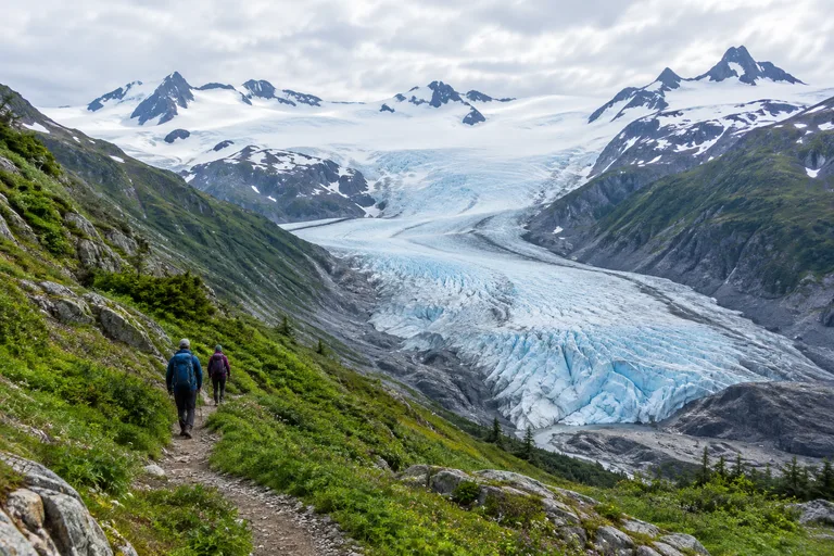
The Harding Icefield Trail is a strenuous day hike of about 8 miles round trip in Kenai Fjords National Park, near Seward, Alaska. It starts beside Exit Glacier, climbs roughly 1,000 feet per mile, and ends at a viewpoint over an icefield of about 700 square miles. The National Park Service says to allow at least 6 to 8 hours. Hikers who do not want the full climb can turn around at Marmot Meadows or Top of the Cliffs, or stay on the short, mostly level trails to Exit Glacier itself.
This guide covers both: the easy Exit Glacier hike on the valley floor and the long climb to the icefield. It explains distance and difficulty, where to turn around, the best months, how to get there from Seward and Anchorage, and what to pack. It also covers bears, snow, and the park rules that matter. The facts come from the National Park Service pages for Kenai Fjords National Park, linked throughout.
Harding Icefield Trail at a Glance
The numbers below come from the National Park Service. The park's own pages do not fully agree on the length, so both figures are shown.
| Detail | What the park says |
|---|---|
| Length | 7.8 miles round trip on the trail page (3.9 miles each way from the trail register). The park fact sheet lists 4.1 miles one way. |
| Climb | About 1,000 feet per mile, approximately 3,500 feet in total |
| Rating | Strenuous |
| Time | At least 6 to 8 hours for the full trail |
| Trailhead | Exit Glacier Nature Center, at the end of Herman Leirer Road near Seward |
| Entrance fee | None. The park charges no entrance fee and requires no pass. |
| Pets | Not allowed on any trail |
| Toilets and bins on the trail | None. Facilities are at the nature center only. |
| Cell service | None in the park, including the Exit Glacier area |
The trail page is the best single source before a trip: Harding Icefield Trail, National Park Service.
Is the Harding Icefield Trail Worth It?
Yes, for hikers who are ready for a hard day. Few maintained trails in the United States lead on foot to the edge of an icefield this large. The route starts in cottonwood and alder forest on the valley floor. It then crosses heather-filled meadows and climbs well above tree line. At the top, ice stretches to the horizon, broken only by nunataks. A nunatak is a lone mountain peak standing above the ice.
The trail also rewards people who stop early. The park says even a short hike up the trail gives impressive views of the valley floor and the end of Exit Glacier. That makes it a good choice for mixed groups. Strong hikers can go for the top while others enjoy the lower trails and the nature center.
The trade-offs are real. The climb is steep from the first mile. The weather changes fast, and snow can linger into July. A clear day is never certain in this rainy corner of Alaska. Families with young children and anyone short on time will usually be happier on the Exit Glacier trails described next.
Exit Glacier: The Easy Walks on the Valley Floor
Exit Glacier sits in the only part of Kenai Fjords National Park that can be reached by road. A network of short trails starts at the Exit Glacier Nature Center and its parking lot. These trails lead to different views of the glacier as it spills down from the Harding Icefield. For most visitors, this is the Exit Glacier hike they have in mind. The park suggests 1 to 2 hours for the lower trails and 30 minutes to an hour for the nature center.
Glacier View Loop Trail
The Glacier View Loop Trail is a one-mile accessible trail. It runs through cottonwood forest to Glacier View, a wide panorama of Exit Glacier, then loops back to the parking area. The park describes this first section as packed gravel and dirt, about 3 feet wide. It suits strollers, wheelchairs, and anyone who wants a gentle walk with a big view.
Glacier Overlook Trail
From the trail-side kiosk, a left turn leads 0.6 miles farther to the Exit Glacier Overlook. The park calls this section moderately strenuous. It gains about 300 feet, and the path is narrower and less even. The lower trails follow the years of the glacier's retreat, and the overlook marks where the ice stood in 2010. Standing there, visitors can see how far the glacier has pulled back since.
Exit Glacier Nature Center
The nature center has exhibits about the Exit Glacier area, a bookstore, and rangers who answer questions. Visitor centers in the park are open from Memorial Day weekend through Labor Day. Flush toilets and a water-bottle filling station run in summer, with pit toilets the rest of the year. Picnic tables and bear-proof bins sit beside the parking lot.
Contact: Exit Glacier Nature Center, 24620 Herman Leirer Road, Seward, AK 99664. Park phone: 907-318-2040. Web: nps.gov, Exit Glacier Area. Hours change by season, so check the official site.
Why the Toe of the Glacier Is Closed
Visitors can no longer walk up to touch the ice. The park has a safety closure from the toe of Exit Glacier to the point where Exit Creek enters the Outwash Plain. The reason is the danger of an outburst flood, which can happen at any time and in any weather. The designated trails stay clear of the flood zone, so the marked paths remain the safe way to see the glacier.
Hiking the Harding Icefield Trail, Section by Section
The trail has three natural goals. Each one is a fair place to stop, eat, and turn around. The table shows how they compare, and the sections below describe each stretch.
| Goal | Distance up the trail | What hikers see | Round trip time |
|---|---|---|---|
| Marmot Meadows | About 1.3 miles | Exit Glacier from above, open meadow | The shortest option. The park gives no set time. |
| Top of the Cliffs | About 2.4 miles | One of the first views of the icefield and its nunataks | 4 to 6 hours |
| End of the trail | 3.9 miles from the trail register | The Harding Icefield, edge to horizon | At least 6 to 8 hours |
The Trailhead to Marmot Meadows
The hike begins on the paved and gravel paths near the nature center. Signs point the way to the trail register, where hikers should sign in. From there the route climbs through cottonwood and alder forest. The grade is steady, and the vegetation is thick. This lower stretch passes salmonberry thickets, a favorite food of black bears, so it is the place to make plenty of noise.
About a third of the way up, the forest opens into Marmot Meadows. The meadow is named for the hoary marmots once seen here often. The park notes they are less common now because more plants have grown in and covered the ground. The reward is a clear view of Exit Glacier from above. For many families, this is far enough.
Marmot Meadows to Top of the Cliffs
The next mile is the steepest part of the whole trail. It climbs a long series of switchbacks up the cliffs above the meadow. Hikers should stay on the path here. The park says cutting switchbacks, together with frequent summer rain, causes serious erosion on this fragile slope.
At about 2.4 miles, the trail reaches Top of the Cliffs. This is one of the first places with a view of the icefield and the peaks that rise through it. The park suggests it as a lunch stop and as a turnaround for hikers short on time. It sits a little past the halfway mark, so it delivers an icefield view without the final snowy stretch.
Top of the Cliffs to the End of the Trail
Above the cliffs, the trail leaves most plants behind. The ground turns to rock, gravel, and patches of snow. Early in the season this stretch can be fully snow-covered. Where snow hides the path, the park places orange flags to mark the route. Snow can also hide hazards such as snow bridges over running water, so careful steps matter.
The trail ends at a viewpoint beside the ice, 3.9 miles from the trail register. A small shelter stands near the top. It is for emergencies only, and camping in it is not allowed. From here the icefield fills the view. The surface is so wide and so white that it can be hard to judge distance. On a clear day, nunataks stand out like dark islands.
Harding Icefield Trail Difficulty: How Hard Is It?
The National Park Service rates the trail strenuous, and that is fair. Three things make it hard.
- The climb never lets up. The trail gains about 1,000 feet for every mile. There are few flat stretches for rest.
- The descent is hard on knees. Everything gained must be walked back down, often on wet rock or soft snow.
- The weather is part of the challenge. The park warns of storms, high winds, intense sunlight, and sudden temperature changes.
No climbing skill is needed in mid-summer when the trail is clear. Hikers who are comfortable with a long, steep day on rough ground can finish it. People new to hiking should pick Marmot Meadows or Top of the Cliffs as the goal. There is no shame in turning around. The mountain views improve with almost every switchback, so a partial hike is still a full experience.
Outside the summer season, the picture changes. In May, June, October, and November, the park describes the route as a mountaineering route. Steep snow, hard route-finding, and avalanche hazard are all possible. The park recommends skills such as self-arrest and avalanche terrain recognition for those months, along with an ice axe and avalanche rescue gear.
Which Hike Fits the Time Available?
This quick planner matches the time on hand to a sensible goal. Times for the upper goals come from the park. All of them assume summer conditions and a clear trail.
| Time available | Good goal | Best for |
|---|---|---|
| 1 to 2 hours | Glacier View Loop and Glacier Overlook Trail | Families, cruise visitors, anyone with limited mobility (loop section) |
| A relaxed half day | Marmot Meadows, about 1.3 miles up | Active families and first-time hikers who want a taste of the climb |
| 4 to 6 hours | Top of the Cliffs, about 2.4 miles up | Fit hikers who want an icefield view without the full day |
| 6 to 8 hours or more | End of the trail | Experienced hikers with an early start and good weather |
Best Time to Hike the Harding Icefield Trail
Mid-July through early September is the most reliable window. The park says the upper trail is often snow-covered through early July, and avalanche danger may exist until then. In September 2026, for example, the park reported the trail almost fully snow-free, with only a few patches near the end. Wind-driven snow can return to the icefield as early as September.
| Season | Road to Exit Glacier | Trail conditions |
|---|---|---|
| Late October to mid-May | Usually closed to cars because of snow | Deep snow. A mountaineering route with avalanche hazard. |
| Late May and June | Usually open | Lower trails open. Upper Harding Icefield Trail often under steep snow. |
| July | Open | Snow often lingers on the upper trail into early July. Later in the month is better. |
| August to early September | Open | Usually the clearest trail of the year. Nature center open through Labor Day. |
| Mid-September to mid-October | Open until the first lasting snow | Fewer services. New snow possible up high. |
Summer days in Kenai Fjords range from the mid 40s to the low 70s Fahrenheit. Overcast, cool, rainy days are frequent, and sunny days are a bonus. The Exit Glacier area averages close to 200 inches of snowfall a year. For a wider look at the region's seasons, see the guide to the best time to visit Southcentral Alaska.
Before any hike, read the park's Current Conditions page. It lists the road status, the snow line, and any closures.
How to Get to Exit Glacier and the Trailhead
Seward is the base for this hike. The town sits 126 miles south of Anchorage by road. From Seward, the drive to the trailhead is short and simple.
| From | Route | Notes |
|---|---|---|
| Anchorage | Seward Highway south, 126 miles to Seward | The highway number changes from AK-1 to AK-9 about 87 miles from Anchorage. |
| Seward | Seward Highway north to Herman Leirer Road, near mile 3.7, then about 8.6 miles to the parking lot | Locals call it Exit Glacier Road. It is the only road into the park. |
| Anchorage by rail | The Alaska Railroad runs between Anchorage and Seward from May through September | A shuttle or taxi is still needed from Seward to the trailhead. |
| Cruise port in Seward | Shuttle or taxi to Exit Glacier | Many cruises begin or end in Seward in summer. |
Parking and Shuttles
Parking at Exit Glacier is limited. The park says the lot is tightest from about 10:00 am to 3:30 pm in June, July, and August. Hikers aiming for the top should arrive early in the morning. That solves the parking problem and leaves a safe margin of daylight. The park itself runs no shuttle, but private shuttle and taxi services operate between Seward and Exit Glacier. Carpooling and cycling are other options. Leashed pets and bicycles are allowed on the road and in the parking lot, but not on the trails.
Visiting in Winter
The Exit Glacier area is open all year, but the road is usually closed to cars from late October to mid-May. In fall 2026 the park listed the road as closed at the first gate. From that gate, the Exit Glacier area lies 7 miles farther on. The park lists a winter shuttle service for the winter months. Rules for winter travel on the closed road change from year to year, so check the official site first.
Travelers who start in the city can pair this hike with the top things to do in Anchorage before the drive south.
Safety on the Trail: Bears, Weather, Snow and Water
This is a wild mountain trail with no cell service. A little planning removes most of the risk.
Bears
The park says black bears are spotted almost every day from the Harding Icefield Trail. Brush is thick on the lower trail, and a surprised bear is the main concern. These steps come from the park's advice:
- Hike in a group and talk loudly, most of all in thick brush.
- Carry bear spray where it can be reached fast.
- Back away slowly from any bear.
- Watch for cubs. A cub in a tree means the mother is close. Never get between them.
For more on the animals of the park, see the Kenai Fjords wildlife guide.
Weather and Snow
Conditions at the top can differ sharply from the parking lot. Rain at the nature center can be wind and sleet near the icefield. A park weather station sits on a nunatak at 4,200 feet in the northeastern part of the icefield. In its first three full years it recorded a high of 68 degrees Fahrenheit, a low of 21 below zero, and a gust of 117 miles per hour. Summer hikers will not meet the worst of that, but the numbers show how exposed the high country is.
On snow, follow the orange flags where the park has placed them. Hiking into avalanche terrain is not recommended without training and proper gear.
Water
The park says to carry at least 2 liters of water per person, or bring a filter. Streams cross the trail, but untreated water may carry Giardia, a parasite that causes severe stomach illness.
What to Pack for the Harding Icefield Trail
Pack for four seasons in one day. The list below follows the park's own advice for summer hikers.
- Sturdy footwear with good grip, ideally waterproof
- Rain gear, both jacket and pants
- Warm layers, including a hat and gloves, even in August
- Sunglasses and sunscreen, since sun on snow is intense
- At least 2 liters of water per person, or a water filter
- Lunch and extra high-energy snacks
- Bear spray, and the knowledge of how to use it
- Trekking poles, which help most on the descent
- A bag for all trash, including used toilet paper
- A paper map or a downloaded map, because phones have no signal
Reusable water bottles are sold in the nature center bookstore in summer. The filling station beside the restrooms is the last tap before the trail.
Park Rules Hikers Should Know
The rules here protect a fragile alpine slope and the people on it.
- No pets on trails. This applies at all times. Service animals are the exception.
- No bikes on trails. The trails are for foot traffic only.
- Stay on the trail. Alpine plants are fragile, and volunteers rebuild the trail every year.
- Pack out everything. There are no bins or toilets on the trail.
- Human waste: dig a small hole at least 100 feet from the trail and from any water, then fill it in.
- Camping along the trail is allowed, but only at least 1/8 mile from the trail, on bare rock or snow.
- The shelter at the top is for emergencies only.
Camping and Where to Stay Near Exit Glacier
Seward is the nearest town and the usual base for the hike. The park points RV travelers to campgrounds in Seward and the nearby national forest. Inside the park, the choices are simple.
Exit Glacier Campground
The park's only campground has 12 tent-only sites. It sits about a quarter mile before the nature center. Key facts from the park:
- Free, with no reservations and no permit. Sites are first come, first served.
- Sites 1 and 12 are accessible.
- The stay limit is 14 days, with up to two tents or eight people per site.
- Cooking and food storage at the tent sites are prohibited. A central shelter is provided for storing food, cooking, and eating.
- A pump supplies drinking water, and pit toilets are available.
- Pets are not permitted in the campsites.
- Sleeping in vehicles is not allowed, and the park has no RV sites.
The campground often fills by early evening in July and August. Hikers who want a site should arrive early in the day. Details are on the park's camping page.
Willow Cabin in Winter
The park also manages Willow Cabin in the Exit Glacier area. It is a public use cabin offered in the winter months by contacting the park. Nightly rates and booking rules change, so check the official site.
Ranger Walks and Programs at Exit Glacier
Free ranger programs are one of the best parts of a summer visit. They run from Memorial Day weekend to Labor Day. In summer 2026 the schedule looked like this:
- Ranger-led walks: daily at 10:00 am and 2:00 pm, about 90 minutes, along the trail to the Glacier Overlook. The first part is wheelchair accessible.
- Pavilion talks: a 20-minute talk once a day in the pavilion near the nature center.
- Junior Ranger walks: about 90 minutes on set days, with same-day sign-up at the nature center.
No reservations are needed for the walks and talks. Times change each year, so confirm them on the park's ranger programs page.
The Harding Icefield: What Hikers Are Looking At
The icefield at the top of the trail is the largest feature in Kenai Fjords National Park. It covers about half the park. A few facts help the view make sense.
- Size: about 695 square miles of ice in total. Roughly 425 square miles lie inside the park.
- Reach: about 50 miles across at its longest point and 20 miles at its widest.
- Glaciers: at least 38 glaciers flow out from it. Exit Glacier is one of them.
- Snow: moist air from the Gulf of Alaska drops an average of about 60 feet of snow on it each year.
- Age: it formed more than 23,000 years ago, as part of a vast ice sheet over Southcentral Alaska.
- Height: the highest ice surface is about 5,200 feet above sea level.
The ice is thousands of feet thick, yet it does not bury the mountains fully. That is why nunataks poke through. Different glaciers end in different ways. Some, such as Aialik Glacier, reach the sea. Exit Glacier ends on land, which is why visitors can drive and walk to it. The sea-level glaciers are best seen by boat, as the Kenai Fjords trip planning guide explains.
The ice is shrinking. The park reports that from 1950 to 2005, the glaciers in and around the park lost 11.2 percent of their ice. The 2010 marker at the Exit Glacier Overlook makes that change easy to see.
A Short History of Crossing the Ice
Alutiiq and Dena'ina people likely traveled onto the ice long ago, though no early crossing is on record. The first known crossing came in 1940. Eugene "Coho" Smith and Don Rising traveled from Bear Glacier to Tustumena Lake. In 1968, a mountaineering party left Homer on horseback and made the first ascent of Truuli Peak. Part of that group then crossed the icefield and skied down Exit Glacier. The trip took eight days. The park still describes a crossing as more of an expedition than a hike.
Hidden Gems Around Exit Glacier
A few quiet details reward visitors who slow down.
- The retreat story on the lower trails. The valley trails trace where the ice once stood. Young forest near the parking lot gives way to bare rock near the glacier. It is a living lesson in how land recovers after ice.
- Glacier scratches in the rock. Near the glacier, the bedrock shows striations. These grooves were cut by stones dragged under the moving ice, and they show the direction it flowed.
- The pavilion talk. Many visitors walk past the pavilion on the Glacier View Loop. The short ranger talk there adds a great deal to the walk that follows.
- Marmot Meadows as a goal of its own. Most trip reports focus on the summit. The meadow gives a fine view down onto Exit Glacier for a fraction of the work.
- The weather station nunatak. Somewhere out on the white horizon, a park weather station logs wind and snow every hour. It is a reminder that scientists study this ice year after year.
- Nearby trails that allow dogs. The park notes that many trails in the nearby national forest and state park lands allow pets. Travelers with a dog can ask at the Seward visitor center for ideas.
Sample Plans: Half Day, Full Day and Two Days
Half Day: Exit Glacier With the Family
- Arrive before 10:00 am to find parking.
- Visit the nature center and join the 10:00 am ranger walk if it is running.
- Walk the Glacier View Loop, then continue to the Glacier Overlook.
- Picnic at the tables beside the parking lot, then return to Seward.
Full Day: The Harding Icefield Trail
- Check the Current Conditions page the night before.
- Be at the trailhead early in the morning, and sign the trail register.
- Take a first break at Marmot Meadows.
- Eat lunch at Top of the Cliffs, and judge the weather and the group's energy.
- Continue to the end of the trail only if both look good.
- Allow as much time for the descent as the legs need.
Two Days: Ice From Land and Sea
- Day one: hike the Harding Icefield Trail or the Exit Glacier trails.
- Day two: see the tidewater glaciers and marine wildlife from the water. A boat tour or a paddle shows the other side of the same icefield. The Kenai Fjords kayaking guide covers the options.
Insider Tips for the Harding Icefield Trail
- Start early. An early start beats the parking crush and leaves time for a slow, safe descent.
- Pick a turnaround time, not just a place. Agree on it before the hike and keep to it.
- Call the recorded line. The park's information line, 907-318-2088, gives current conditions without the need for a data signal later.
- Fill bottles at the nature center. It is the last treated water.
- Tell someone the plan. With no cell service, a contact in town should know the route and return time.
- Save the trail for the clearest day. Travelers with two or three days in Seward can check the forecast and choose.
- Stop at the Seward visitor center first. Rangers there can share the latest trail report. Kenai Fjords National Park Visitor Center, 1212 4th Avenue, Seward, AK 99664. Phone: 907-318-2064 in summer. Web: nps.gov/kefj.
Frequently Asked Questions
How long is the Harding Icefield Trail?
The National Park Service trail page lists the Harding Icefield Trail as a 7.8-mile round trip, with the end of the trail 3.9 miles from the trail register. Other park materials list 4.1 miles one way, or 8.2 miles round trip. Plan on about 8 miles and at least 6 to 8 hours.
How hard is the Harding Icefield Trail?
The National Park Service rates the trail strenuous. It gains about 1,000 feet for every mile, roughly 3,500 feet in all, and the upper part is often under snow into early July. Fit hikers with good footwear, layers and plenty of water manage it as a full day.
Can you hike only part of the Harding Icefield Trail?
Yes. Marmot Meadows, about 1.3 miles up, gives views of Exit Glacier from above. Top of the Cliffs, about 2.4 miles up, gives one of the first views of the icefield and takes 4 to 6 hours round trip. Even a short climb shows the valley floor and the end of Exit Glacier.
Can you walk to Exit Glacier without a long hike?
Yes. The Glacier View Loop Trail is a one-mile accessible loop from the Exit Glacier Nature Center to a wide view of the glacier. The Glacier Overlook Trail continues 0.6 miles from the trail kiosk to a closer overlook and is moderately strenuous.
When is the best time to hike the Harding Icefield Trail?
Mid-July through early September is the most reliable window for a snow-free or nearly snow-free trail. The upper trail is often snow-covered through early July, and in May, June, October and November the park treats the route as a mountaineering route with avalanche hazard.
Does it cost anything to visit Exit Glacier?
No. Kenai Fjords National Park charges no entrance fee and requires no park pass. The 12-site tent campground at Exit Glacier is also free and first come, first served. Check the official park site before a trip in case this changes.
Are dogs allowed on the Harding Icefield Trail?
No. Pets are not allowed on any trail in the Exit Glacier area at any time. Leashed pets are allowed on the road to Exit Glacier and in the parking lot. Service animals are the exception on the trails.
Are there bears on the Harding Icefield Trail?
Yes. The National Park Service says black bears are spotted almost every day from the trail, which passes salmonberry thickets that bears feed in. Hike in a group, make noise, carry bear spray and never get between a mother bear and her cubs.
Can you walk on the Harding Icefield or Exit Glacier?
The maintained trail ends at a viewpoint beside the icefield, not on it. Travel on the ice is for skilled mountaineers with glacier equipment, and the park describes a crossing as more of an expedition than a hike. The canyon at the toe of Exit Glacier is closed because of outburst flood danger.
Is the road to Exit Glacier open in winter?
Usually not for cars. Herman Leirer Road is typically closed to automobiles from late October to mid-May because of snow. The area itself stays open all year. Check the park's Current Conditions page or call the recorded information line at 907-318-2088.
Planning your next U.S. getaway? Explore more destination guides, road trips, and travel tips at Vacation Getaways US. Have a question or a spot we should cover? Email us at [email protected].