
How To Plan An Amazing Weekend Getaway: Tips For Your Next Trip
May 21, 2021
Simple steps for planning a short trip, from picking dates to booking a place to stay.
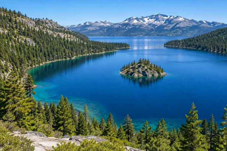
This Lake Tahoe travel guide answers the first questions fast. Lake Tahoe is a mountain lake on the California and Nevada border, 22 miles long and ringed by 72 miles of shoreline. It is a true two-season trip: beaches, boating and hiking in summer, and skiing at more than a dozen resorts in winter. First-time visitors usually base themselves in South Lake Tahoe for Emerald Bay and Heavenly, or on the north shore for quieter towns and state park beaches. Three days is a good start.
The sections below compare north vs south Lake Tahoe, set out the best time to visit Lake Tahoe by season, and list the top things to do in Lake Tahoe in summer and in winter. The lake is a highlight of both the California travel guide and the Nevada travel guide, since the state line runs through the water. It suits families, couples and solo travelers equally well.
The lake facts below come from the US Forest Service, which manages most of the land in the Tahoe basin.
| Question | Short answer |
|---|---|
| Where is it? | In the Sierra Nevada, on the California and Nevada state line |
| How big is the lake? | 22 miles long, 12 miles wide, 72 miles of shoreline |
| How deep? | 1,645 feet at its deepest point |
| How high? | The surface is about 6,225 feet above sea level |
| Closest airport | Reno-Tahoe International, about 45 minutes from the north shore and an hour from the south shore |
| Drive from the Bay Area | About 3.5 hours in good conditions |
| Main seasons | Summer for the lake, winter for snow |
| How long to stay | Three days for a first visit, a week to see both ends |
A few more numbers explain why the water looks the way it does. Sixty-three streams flow into Lake Tahoe and only one river, the Truckee, flows out. The lake holds about 37 trillion gallons. The Forest Service notes that in the 1860s objects could be seen 100 feet below the surface, and that clarity has dropped by about a quarter in recent decades. Protecting that clarity is a shared goal around the lake.
South Lake Tahoe is the lively end, and North Lake Tahoe is the quiet one. That is the short version of the north vs south Lake Tahoe question, and for most trips it is enough to choose a base. The details are in the table.
| South Lake Tahoe | North Lake Tahoe | |
|---|---|---|
| Feel | A small city with casino hotels on the Nevada side, concerts and nightlife | A string of small towns on the west, north and east shores |
| Main towns | South Lake Tahoe in California, Stateline and Zephyr Cove in Nevada | Tahoe City, Kings Beach, Incline Village, with Truckee nearby |
| Signature sights | Emerald Bay, Heavenly and its gondola, Heavenly Village | Sand Harbor, the west shore state parks, Olympic Valley |
| Ski resorts | Heavenly, Kirkwood, Sierra-at-Tahoe | Palisades Tahoe, Northstar California, Diamond Peak, Mt. Rose and more |
| Closest airport drive | About an hour from Reno | About 45 minutes from Reno |
| Free local transit | Lake Link shuttle and public buses | TART buses and TART Connect |
| Best for | First visits, groups, entertainment, an easy trip to Emerald Bay | Quiet beach days, families who like small towns, a wide choice of ski hills |
The south shore packs the most into the smallest area. The Lake Tahoe Visitors Authority counts roughly 150 places to stay there. Heavenly Mountain Resort straddles the state line, and Heavenly Village has shops and an outdoor ice rink in winter. Summer brings a concert series at the casino hotels, which sit on the Nevada side. Emerald Bay, one of the most photographed spots on the lake, is 12 miles up Highway 89.
The north shore's tourism office defines its region as everything from Emerald Bay around to Spooner Summit, which covers the west, north and east shores. It counts 12 towns and two mountain villages there. Tahoe City and Kings Beach are California beach towns, Incline Village sits on the Nevada side, and Truckee, north of the lake, has the Amtrak station. The pace is slower, with more public beaches and small towns, and most of the ski resorts are on this side.
Yes. A drive around the lake takes in all four shores, and it fills a day with stops at Emerald Bay, Tahoe City, Kings Beach and Sand Harbor. On a longer stay, split the nights between the two ends so that no day begins with a long drive.
The best time to visit Lake Tahoe is July and August for the beach, December through March for snow, and September for the best mix of weather and elbow room. The South Shore tourism office counts about 300 days of sunshine a year, so no season is a bad bet.
| Season | What it is good for | What to know |
|---|---|---|
| Summer, June to August | Beaches, boating, paddling, hiking, biking, outdoor concerts and the Lake Tahoe Shakespeare Festival at Sand Harbor in July and August | Parking at beaches and Emerald Bay fills early. Sand Harbor needs a morning reservation for cars. |
| Fall, September to November | Hiking, mountain biking, fall color and the kokanee salmon run at Taylor Creek in late October | State park services wind down from October 1. Some gates close to cars. |
| Winter, December to March | Skiing and snowboarding, cross-country skiing, snowshoeing, tubing, sleigh rides | Chain controls on the highways. Many lake parks have no water or restrooms. |
| Spring, April to May | Late-season skiing up high and quiet trails by the lake | Weather swings between snow and sun. Summer services have not started yet. |
Travel writers who know the lake tend to agree on two points. Spring and fall bring the lightest crowds, and weekdays are calmer than weekends in every season. Ski resorts often aim to open around Thanksgiving, but opening and closing dates depend on snow, so check each resort before booking.
Most visitors drive, and most of the rest fly into Reno. The times below are the ones published by the tourism offices for each shore, and they assume clear roads.
| From | To South Lake Tahoe | To North Lake Tahoe |
|---|---|---|
| Reno-Tahoe International Airport | About 1 hour | About 45 minutes |
| Sacramento International Airport | About 2 hours | About 2 hours |
| San Francisco, Oakland and San Jose airports | About 3.5 hours | About 3.5 hours |
The South Tahoe Airporter runs express buses several times a day from the Reno airport to the south shore, and the North Lake Tahoe Express links the same airport with the north shore and Truckee. Amtrak's California Zephyr stops in Truckee every day, with other stops between the Bay Area and Denver. A connector bus route also links Sacramento and South Lake Tahoe.
The roads to the lake climb high into the mountains, and winter storms bring chain controls. Caltrans uses three levels:
The speed limit under chain control is 25 or 30 miles an hour. Call the Caltrans road line at 800-427-7623 before leaving, and carry chains from November through April even when the forecast looks clear.
A car is the simplest way to circle the lake, but both shores have free local transit that solves the parking problem.
The South Shore tourism office suggests reaching Emerald Bay and the beaches by about 9 am on weekends and holidays, or parking in town and biking in.
Summer is lake season. The best things to do in Lake Tahoe between June and September all involve the water or the trails above it. Go out early: the South Shore tourism office says the lake is smooth as glass in the morning.
Emerald Bay State Park is the one stop no first visit should skip. It is 12 miles north of South Lake Tahoe and 22 miles south of Tahoe City on Highway 89, and it is open from sunrise to sunset. The view from the top is free of effort. The rest takes some work:
Beaches ring the lake, and many of the best known are in state parks. Fees are those listed in November 2026, so check each official page before a visit.
| Beach or park | Shore | Why go | Day-use fee |
|---|---|---|---|
| Sand Harbor, Lake Tahoe Nevada State Park | East, Nevada | Gently sloping beaches and clear water | $10 per vehicle, $15 for vehicles from outside Nevada |
| Kings Beach State Recreation Area | North, California | A sandy town beach with a playground and picnic tables | $10 per vehicle or $3 an hour, cards only |
| D.L. Bliss State Park | West, California | Lester Beach, Calawee Cove and Rubicon Point | $10 per vehicle |
| Ed Z'berg Sugar Pine Point State Park | West, California | Nearly two miles of lakefront and a 1903 mansion | $10 per vehicle |
| Emerald Bay State Park | Southwest, California | Vikingsholm and the bay itself | $10 per vehicle |
| Pope Beach, Baldwin Beach, Nevada Beach, Zephyr Cove | South | The beaches the South Shore tourism office names first | Check the official site |
Sand Harbor is the east shore's showpiece, with gently sloping beaches and water clear enough for scuba diving. The catch is the entry rule. From May 15 through September 30, cars need a day-use reservation to enter during the morning window, every day. The park's own page gave two end times for that window, 10:00 and 10:30 am, so confirm it when booking. The park opens at 8 am and closes one hour after sunset. A paved three mile path, the East Shore Trail, links Incline Village with the park, and bike entry was $2 in 2026. A new 130 space lot at Chimney Beach on State Route 28 adds more parking for Sand Harbor visitors. Pets are allowed only from October 15 to April 15.
Contact: Sand Harbor, Lake Tahoe Nevada State Park, 2005 Highway 28, Incline Village, NV 89450. Phone: 775-831-0494. Web: parks.nv.gov.
Contact: Tahoe Rim Trail Association, 128 Market Street, Suite 3E, Stateline, NV 89449. Phone: (775) 298-4485. Web: tahoerimtrail.org.
The south shore offers boat trips to Emerald Bay, kayak and paddleboard rentals, parasailing, fishing charters and jet skis. The north shore adds kayaking from its state park beaches, and Kings Beach has a ramp for boats without motors. Mountain bikers on the south shore head for the Corral Trail and Mr. Toad's Wild Ride, while families stick to the paved South Lake Tahoe Bike Path.
The Forest Service's Taylor Creek Visitor Center sits about three miles northwest of South Lake Tahoe on Highway 89, just past the Tallac Historic Site. Its Stream Profile Chamber is the main draw. Kokanee salmon are known to head upstream in late October. The buildings usually open from June through October, the grounds stay open all year, and there is no fee.
Winter turns the mountains around the lake into ski country. The north shore's tourism office counts 11 downhill resorts in its region alone, and the south shore promotes three more.
| Resort | Side of the lake | Known for |
|---|---|---|
| Heavenly Mountain Resort | South, on the state line | 4,800 acres, 34 miles of groomed runs and lake views from the gondola |
| Kirkwood Mountain Resort | South | A remote setting, deep powder and steep, challenging terrain |
| Sierra-at-Tahoe | South | Wide beginner terrain, terrain parks and a well-regarded ski school |
| Palisades Tahoe | North | Its home in Olympic Valley, California |
| Northstar California | North | Its base in Truckee, California |
| Diamond Peak | North | Skiing in Incline Village, Nevada |
| Mt. Rose | North | Skiing on the Nevada side |
Lift tickets, hours and season dates change every year, so check each resort's own site. Skiers who want variety can stay in one town and try a different mountain each day.
State parks stay open in a reduced way. At D.L. Bliss the gate closes to cars from October 1 and visitors walk in. At Emerald Bay there are no services or drinking water from October to May. Sugar Pine Point keeps one campground loop open for winter camping, first come, first served. Sand Harbor welcomes leashed dogs from October 15 to April 15, the one time of year they are allowed.
Choose the base first, then the bed. The right town matters more here than the right hotel, because parking at the popular spots fills early and a short trip in the morning is worth a lot.
Campers should check the state park pages early. In 2026 the Eagle Point and boat-in campgrounds at Emerald Bay were closed for the season, and D.L. Bliss camping was closed until May 2027. Reservations for other state park campgrounds open months ahead. Travelers who want walls and a stove can browse cabin camping ideas.
Lake Tahoe's clear water is the reason people come, and the parks around it enforce rules to keep it that way. A fire ban covered campfires and charcoal in state park day-use areas in the Sierra District in November 2026. At the D.L. Bliss campground, food must stay in the lockers provided, day and night. Drones, fires and bicycles are not allowed on the Rubicon Trail. Staying on marked trails and packing out trash help keep the lake blue.
May 21, 2021
Simple steps for planning a short trip, from picking dates to booking a place to stay.

May 21, 2021
Ways to compare fares and find flight deals before booking a trip to California.

April 28, 2021
A checklist of what to pack for a two or three day trip in any season.
The best time to visit Lake Tahoe depends on the trip. July and August are best for beaches and boating. December through March is ski season. September and early October bring warm days, open trails and far fewer people, which makes early fall the best all-around choice for many travelers.
South Lake Tahoe is better for first visits, nightlife, casinos, Heavenly and quick access to Emerald Bay. North Lake Tahoe is better for quiet beach towns, state parks on the west and east shores, and the largest choice of ski resorts. The two ends are close enough to see both on one trip.
Three days is a good first visit. That allows one day for Emerald Bay and the south shore, one day for the north and east shores with Sand Harbor, and one day for a hike, a boat trip or a ski day. A week lets travelers split their stay between both ends of the lake.
Reno-Tahoe International Airport is the closest commercial airport. It is about a 45 minute drive from North Lake Tahoe and about an hour from South Lake Tahoe. Sacramento International Airport is about two hours away, and the San Francisco Bay Area airports are about three and a half hours away.
The drive from the San Francisco Bay Area to Lake Tahoe takes about three and a half hours in good conditions, according to the tourism offices for both the north and south shores. Winter storms and weekend traffic can make it much longer.
Yes, in summer. Nevada State Parks requires a day-use reservation for vehicles entering Sand Harbor during the morning entry window every day from May 15 through September 30. Check the park page for the exact hours before a visit.
Yes, with care. California State Parks says Vikingsholm can be reached on foot all year, but snow and ice make the steep trail hazardous, and there are no services or drinking water from October to May. Chains or four-wheel drive are often required on Highway 89.
Often, yes. Caltrans sets chain controls on mountain highways during storms. Under the most common levels, cars need chains or snow tires, and even four-wheel drive vehicles with snow tires must carry traction devices. Call the Caltrans road line at 800-427-7623 before driving.
Yes, within each shore. On the south shore, Lake Link is a free on-demand shuttle and the public buses are free. On the north shore, TART buses and the TART Connect on-demand service are free. A car is still the easiest way to travel between the north and south ends.
Lake Tahoe is 22 miles long and 12 miles wide, with 72 miles of shoreline, according to the US Forest Service. Its deepest point is 1,645 feet, and its surface sits about 6,225 feet above sea level.
Planning your next U.S. getaway? Explore more destination guides, road trips, and travel tips at Vacation Getaways US. Have a question or a spot we should cover? Email us at [email protected].