
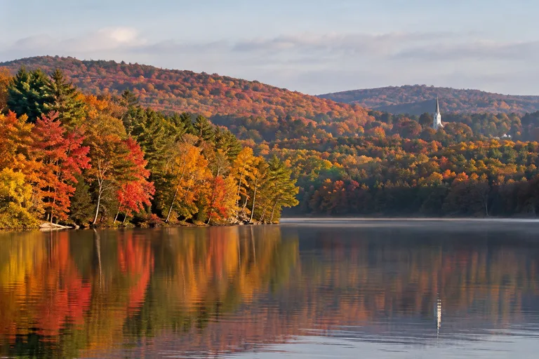
The Litchfield Hills, CT, are the quiet hill country of northwest Connecticut, known for small towns, waterfalls, lakes and the state's first fall color. The top stops are the town green in Litchfield, Kent Falls State Park, the West Cornwall Covered Bridge and Lake Waramaug. This guide covers the towns, the parks, a fall foliage drive, a two-day plan and insider tips for families and couples. For the rest of the state, see the Connecticut travel guide.
Where Are the Litchfield Hills?
The Litchfield Hills fill the northwest corner of Connecticut, in Litchfield County. The region runs from Litchfield and Washington in the south to Norfolk and Salisbury in the north. New York lies to the west and Massachusetts to the north. The Connecticut Office of Tourism describes the region as rolling hills with antiques shops, art galleries, historic homes, gardens and romantic inns.
A few quick facts help with planning:
- Distance: the state tourism office places Salisbury about two hours north of New York City and one hour west of Hartford.
- Season: this is the first part of Connecticut to see fall color.
- Style: a slow trip of short drives, village walks, easy hikes and long lunches.
- Cost: most state parks here are free for vehicles registered in Connecticut, and several are free for everyone.
Is the Litchfield Hills Region Worth Visiting?
Yes. The Litchfield Hills suit travelers who want a calm New England trip without a long drive. Couples come for inns, vineyards and foliage. Families come for waterfalls, lake swimming and easy trails with a tower at the top. History fans get the site of the nation's first law school and a covered bridge in service since 1864.
The trade-off is that the region is spread out. There is no single center, and a car is needed. A good trip picks two or three towns and a few parks, and leaves time to stop along the way.
Litchfield Hills at a Glance
Use this table to match the stops to the trip. Fees and hours change, so check each official site before going.
| Stop | Town | Best for | Cost |
|---|---|---|---|
| Litchfield Green and historic sites | Litchfield | History, shops, lunch | Museums free |
| White Memorial Conservation Center | Litchfield | Easy trails, families | Trails free, check the site for the museum |
| Topsmead State Forest | Litchfield | Picnics, a Tudor-style cottage | Free |
| Mount Tom State Park | Litchfield | Tower hike, pond swimming | Free for Connecticut vehicles |
| Kent Falls State Park | Kent | Waterfall, short steep climb | Free for Connecticut vehicles |
| Macedonia Brook State Park | Kent | Ridge hiking, rustic camping | No parking fee |
| Lake Waramaug State Park | New Preston | Swimming, paddling, camping | Free for Connecticut vehicles |
| West Cornwall Covered Bridge | Cornwall | Photos, a river stop | Free |
| Mohawk State Forest | Cornwall and Goshen | Long views, a bog boardwalk | Free for Connecticut vehicles |
| Haystack Mountain State Park | Norfolk | Tower views to three states | Free |
Litchfield County Small Towns to Visit
The Litchfield County small towns are the heart of a trip here. Each has its own feel, and none is far from the next. Start with Litchfield, then add one or two more.
Litchfield
Litchfield is the classic first stop. The Connecticut Office of Tourism describes it as a picture-perfect rural town with a walkable downtown. Shops and restaurants line the historic Green. The town's story reaches back to the War of Independence, when George Washington met Colonel Tallmadge here.
The top sight is the Tapping Reeve House and Litchfield Law School on South Street. The Litchfield Historical Society calls it the nation's first law school. It ran from 1774 to 1833 and taught over 1,000 young men. The society lists these among its graduates:
- 2 vice presidents
- 101 members of the U.S. House and 28 U.S. senators
- 3 justices of the U.S. Supreme Court
- 14 governors
The law school and the Litchfield History Museum are both free. The society lists them as open Wednesday through Sunday. A walking tour map of the town is sold for a small fee. Check the society's visit page for current days.
Kent
Kent sits on Route 7 beside the Housatonic River. The state tourism office says the town balances old and new, with owner-run shops and galleries that show both contemporary and classic art. Parking in the village center is ample, which makes it an easy lunch stop.
Kent packs a lot into one town:
- Kent Falls State Park, with 250 feet of cascades
- Macedonia Brook State Park, for ridge hikes
- A historic covered bridge over the river
- The Appalachian Trail
- The Eric Sloane Museum and Kent Furnace
- Seven Hearths Museum, a 1751 house that was the home of artist George Laurence Nelson
Washington and New Preston
Washington is a town of about 4,000 people, set among farmland, rolling hills and quiet roads. According to the state tourism office, Washington inspired the fictional town of Stars Hollow in the Gilmore Girls series. Artists, musicians and writers have long come here, and the town has several art galleries.
Places to visit include Hollister House Garden, the Gunn Memorial Library and Historical Museum, and the Institute for American Indian Studies. The institute began in 1975 and is open Thursday through Sunday. Lake Waramaug is close by, and its state park is covered below.
Contact: Institute for American Indian Studies, 38 Curtis Road, Washington, CT 06793. Phone: (860) 868-0518. Web: iaismuseum.org.
Cornwall and West Cornwall
Cornwall calls itself the "Home of the Covered Bridge." The West Cornwall Covered Bridge crosses the Housatonic River on Route 128 and still carries cars. It is 172 feet long and has been in continuous service since 1864. The bridge is listed on the National Register of Historic Places and is one of the last covered bridges in Connecticut.
The river here is known for rafting, canoeing and fly fishing. Cornwall is also home to Mohawk Mountain Ski Area and Mohawk State Forest.
Norfolk
Norfolk sits in the foothills of the Berkshires, near the Massachusetts border. The town was established in 1758. It is a music town, home to the Norfolk Chamber Music Festival and Infinity Music Hall. It also has a curling club, a farmers market and three state parks: Haystack Mountain, Dennis Hill and Campbell Falls.
Salisbury and Lakeville
Salisbury fills the far northwest corner of the state. Its villages include Lakeville, Taconic, Lime Rock and Amesville. The town has mountains for hiking, lakes for fishing and canoeing, and easy access to the Appalachian Trail. Visitors can boat on Lake Wononscopomuc or Twin Lakes.
Salisbury has two unusual draws. Lime Rock Park hosts car racing, including international vintage car races. The town is also known for ski jumping competitions. Its historic sites recall the iron ore industry of the 1800s.
Kent Falls State Park
Kent Falls State Park is the waterfall stop of the Litchfield Hills, and the visit is easy. Connecticut State Parks says the water cascades 250 feet down to the Housatonic River. The main plunge is about 70 feet, followed by a series of smaller falls.
The walk has two parts:
- To the base: a paved path leads from the parking lot across a covered bridge to the foot of the falls. This path is accessible.
- To the top: the Kent Falls Steps Trail is a 0.84-mile out-and-back route rated moderate. Stone stairs climb about a quarter mile beside the falls. It is short but steep.
The park has picnic tables near the covered bridge. It is one of thirteen state trout parks in Connecticut, and the best fishing spots are below the base of the falls. Leashed pets are allowed in the picnic areas and on the trails.
Know the rules before going:
- No swimming or entering the water
- No alcohol
- No drones
- Stay on the hiking trails
The falls run all year. Spring brings the heaviest flow during snowmelt, and a summer rainstorm can do the same. Fall color makes the park very popular. Parking is free for vehicles registered in Connecticut. Out-of-state vehicles pay a fee that is higher on weekends and holidays.
Contact: 462 Kent Cornwall Road, Kent, CT 06757. Phone: (860) 927-3238. Web: ctparks.com.
More State Parks and Outdoor Things to Do
The Litchfield Hills hold a strong set of state parks. These six cover towers, lakes, ridges and rivers.
Mount Tom State Park, Litchfield
Mount Tom State Park was established in 1915 and is one of the oldest parks in the state system. A trail of about one mile climbs to a 34-foot stone tower. The summit stands 1,325 feet above sea level. On a clear day the view reaches Mount Everett, the Catskills and Long Island Sound.
The park also has a pond with a swimming beach, open from Memorial Day to Labor Day. Parking is limited. When the lot fills, the park closes to new visitors, so arrive early on warm weekends. The park is on Route 202 in Litchfield. Check the park page for the seasonal phone number.
Lake Waramaug State Park, New Preston
Lake Waramaug State Park covers 95 acres on the shore of a 656-acre lake. Connecticut State Parks calls it the second largest natural lake in the state. The name comes from a chief of the Wyantenock Tribe, and the park page says it translates to "place of good fishing."
The park beach is the only public access point on the lake. In the warm months a vendor rents canoes, kayaks and paddleboards. The campground has 76 sites and six rustic cabins. In fall, the hills reflect on the still water, and the park fills with sightseers and photographers. An eight-mile bike loop circles the lake on narrow, winding roads. It suits experienced riders best.
Contact: 30 Lake Waramaug Road, New Preston, CT 06777. Phone: (860) 868-2592. Web: ctparks.com.
Macedonia Brook State Park, Kent
Macedonia Brook State Park is the pick for a real hike. The park covers about 2,300 acres, with more than 10 miles of trails, steep climbs and scenic overlooks. The Blue Trail crosses Cobble Mountain and several other peaks. Its views reach the Catskill and Taconic mountains, and the park page calls the fall foliage especially striking.
The campground has 51 rustic sites with no showers or running water. Cell service is very limited in the park, so download a trail map first. There is no parking fee.
Contact: 159 Macedonia Brook Road, Kent, CT 06757. Phone: (860) 927-3238. Web: ctparks.com.
Mohawk State Forest, Cornwall and Goshen
Mohawk State Forest covers about 4,000 acres. Mohawk Mountain rises to 1,683 feet. On a clear day the views reach the Catskill, Taconic and Berkshire ranges, and one overlook can be reached by car. The forest has a trail system of about 30 miles.
Its rare feature is the Black Spruce Bog. The bog sits in a glacial sinkhole about 40 feet deep. A short trail and boardwalk protect the plants. The forest is open daily from April through November.
Contact: Route 4, Goshen and Cornwall, CT 06753. Phone: (860) 491-3620. Web: ctparks.com.
Housatonic Meadows State Park, Sharon
Housatonic Meadows State Park lines the Housatonic River along Route 7. It is a favorite for anglers. A two-mile stretch of the river, including the park shore, is limited to catch-and-release fly fishing. The wooded campground has 61 sites and four rustic cabins. Entry to the park is free.
Contact: 90 US Route 7, Sharon, CT 06069. Phone: (860) 927-3238. Web: ctparks.com.
Haystack Mountain State Park, Norfolk
Haystack Mountain State Park has a 34-foot stone tower at its summit, built in 1929. From the top, visitors can see the Berkshires, Massachusetts, New York and the Green Mountains of Vermont. Two routes lead up. One is a paved road about two miles long. The other is the rocky Tower Loop Trail, about one mile long. The park page says to allow about half an hour for the walk.
The park road is open to cars from late April through November. The rest of the year, visitors walk in. Mountain laurel blooms here in early summer, and fall is the best time for foliage. The park is free.
Contact: Route 272, Norfolk, CT 06058. Phone: (860) 482-1817. Web: ctparks.com.
Litchfield Hills Fall Foliage: When and Where
Litchfield Hills fall foliage is the first in Connecticut. The Connecticut Office of Tourism says the region is the first part of the state to see color changes, and the season then moves from north to south over about six weeks. That makes this the place to start a Connecticut leaf trip.
The state's foliage tracker gives these approximate dates. Weather shifts them each year, so check the Connecticut foliage tracker before going.
| Approximate dates | What the state tracker says |
|---|---|
| September 21 to 25 | The first trees change at Peoples State Forest in Barkhamsted. |
| September 26 to 29 | Macedonia Brook State Park in Kent grows richer with color. |
| September 30 to October 2 | The Litchfield Hills Ramble drive is in fine color. |
| October 3 to 8 | Estimated peak viewing for the Ramble. The town of Litchfield looks its best. |
| October 24 to 30 | The northern border towns, such as Norfolk, are past peak. |
The Litchfield Hills Ramble Drive
The state's Litchfield Hills Ramble is a loop of about 100 miles that starts in Torrington. The loops in the state guide were suggested with help from the Connecticut Department of Energy and Environmental Protection. The route runs in this order:
- North on Route 8 to Winsted, then northwest on Route 44 to Canaan or Falls Village
- South on Route 7 to Kent
- East on Route 341 to Warren, then south on Route 45 through New Preston
- East on Route 202 for about a mile, then south on Route 47 to Washington Depot
- Northeast on Route 109 to East Morris, then north on Route 63 to Litchfield
- East on Route 118, then north on Route 8 to close the loop
The loop passes close to many stops in this guide. Kent Falls State Park and Housatonic Meadows State Park are on Route 7. The West Cornwall Covered Bridge is on Route 128, beside the river. Lake Waramaug is at New Preston, and the drive ends with the Litchfield Green.
Best Foliage Views on Foot
- Mount Tom tower: about one mile of trail to a wide view.
- Haystack Mountain tower: a short walk or a drive most of the way, with views into three states.
- Cobble Mountain: the Blue Trail at Macedonia Brook, for hikers who want a climb.
- Lake Waramaug: color reflected on still water, best on a calm morning.
- Mohawk State Forest: an overlook that can be reached by car.
Hidden Gems in the Litchfield Hills
These quieter stops are easy to miss and easy to love.
- Topsmead State Forest, Litchfield: the former summer estate of Edith Morton Chase. Its English Tudor Revival cottage was completed in 1925. Miss Chase left the estate to the people of Connecticut in 1972 and asked that it be kept in a state of natural beauty. Free 30-minute cottage tours run on the second and fourth weekends of each month from June through October. The 510-acre forest has picnic lawns, a butterfly garden and a 0.7-mile ecology trail. Admission is free.
- White Memorial's back roads: the 4,000-acre White Memorial property in Litchfield has about 35 miles of roads and trails that are free and open to the public.
- The Black Spruce Bog: a boardwalk into a late-stage peat bog at Mohawk State Forest, with black spruce and larch of a size rarely seen elsewhere in the state.
- Hopkins Vineyard, Warren: a family farm run by the Hopkins family for over 235 years. The state tourism office notes that tastings overlook Lake Waramaug.
- Campbell Falls, Norfolk: a forest waterfall in a state park reserve.
- Elephant's Trunk in New Milford: a flea market in New Milford. It is one of the picks in this site's list of the best flea markets in the USA.
Contact: Topsmead State Forest, Buell Road, Litchfield, CT 06759. Phone: (860) 567-5694. Web: ctparks.com.
Contact: White Memorial Conservation Center, 80 Whitehall Road, Litchfield, CT 06759. Phone: (860) 567-0857. Web: whitememorialcc.org.
Contact: Hopkins Vineyard, 25 Hopkins Road, Warren, CT 06777. Phone: 860-868-7954. Web: hopkinsvineyard.com.
Things to Do With Kids
The Litchfield Hills work well for families, because the best stops are short and outdoors.
- Kent Falls: the paved path to the base suits strollers. Older children can take the stairs.
- White Memorial Conservation Center: a nature museum and easy trails. The museum is open Tuesday through Sunday.
- Mount Tom: a one-mile climb to a stone tower, then a swim in the pond in summer.
- Lake Waramaug: a beach, boat rentals and a campground in one place.
- Institute for American Indian Studies: exhibits and family programs in Washington.
- Naugatuck Railroad, Thomaston: rail trips run by the Railroad Museum of New England. Check its site for the schedule.
A Two-Day Litchfield Hills Itinerary
Two days cover the best of the region without rushing. This plan keeps the driving short each day.
| Day | Morning | Afternoon | Evening |
|---|---|---|---|
| Day 1: Litchfield and the lake | Walk the Litchfield Green. Visit the Tapping Reeve House and Litchfield Law School. | Climb to the Mount Tom tower, or walk the trails at White Memorial. | Drive to Lake Waramaug for the late light. Stay near the lake or in Litchfield. |
| Day 2: Kent and the river | Kent Falls State Park. Arrive early for parking. | Lunch and galleries in Kent, then north on Route 7 to the West Cornwall Covered Bridge. | Return through Cornwall and Goshen on Route 4, with a stop at Mohawk State Forest in season. |
With a third day: head north to Norfolk for the Haystack Mountain tower and to Salisbury for the lakes. This also sets up a drive into the Berkshires. See the Massachusetts travel guide for that leg.
With only one day: choose Litchfield plus Kent Falls, or drive the Litchfield Hills Ramble with three short stops.
Best Time to Visit the Litchfield Hills
Fall is the best-known season, but each season has a clear reason to come. This table uses dates posted by the parks and the state tourism office.
| Season | Why go | Good to know |
|---|---|---|
| Spring | Kent Falls runs at its heaviest during snowmelt. | The Haystack Mountain road opens in late April. Mohawk State Forest lists daily hours from April. |
| Summer | Swimming at Mount Tom and Lake Waramaug from Memorial Day to Labor Day. Mountain laurel at Haystack in early summer. Topsmead cottage tours start in June. | Small parking lots fill on warm weekends. |
| Fall | The first foliage in the state, with estimated peak in early October. | A popular time. Book rooms early and visit parks on weekdays if possible. |
| Winter | Skiing at Mohawk Mountain and Ski Sundown. Free cross-country skiing and snowshoeing at White Memorial. | The Haystack road closes to cars. Mohawk State Forest lists daily hours from April through November only. |
Winter in the Hills
The state tourism office describes winter sports in the Litchfield Hills in detail. Mohawk Mountain Ski Area in Cornwall is described as the oldest and largest ski area in Connecticut, with 25 trails, night skiing and snow tubing. Ski Sundown in New Hartford has 16 trails, with 15 of them lit for night skiing. Topsmead State Forest is a listed sledding spot, and Kent Falls stays open all year.
Getting to the Litchfield Hills and Getting Around
The Litchfield Hills are a driving region. Plan on a car for the whole trip. The towns are small and the parks are spread along country roads.
| Road | What it connects |
|---|---|
| Route 7 | The west side, along the Housatonic River: Kent, Kent Falls, Housatonic Meadows, Falls Village |
| Route 8 | The east side: Torrington and Winsted |
| Route 44 | The north: Winsted to Canaan |
| Route 202 | Litchfield, Mount Tom and New Preston |
| Route 63 | East Morris north to Litchfield |
| Route 4 | Goshen, Mohawk State Forest and Cornwall |
From New York City, the state tourism office puts Salisbury about two hours north. From Hartford, it is about one hour west. Visitors who fly can use Bradley International Airport near Hartford and rent a car. See the New York travel guide for trips that start in the city.
Driving tips: many of the roads are narrow and winding, so allow extra time between stops. Cell service drops in places, and the state warns that it is very limited at Macedonia Brook State Park.
Where to Stay in the Litchfield Hills
The region is known for country inns and bed and breakfasts, and the state tourism office lists many of them on its Litchfield Hills page. Pick a base by the kind of trip:
- Litchfield: best for a first visit, with the Green, restaurants and three parks close by.
- Kent: best for hikers and for Kent Falls at opening time.
- Washington and New Preston: best for couples who want a lake, a vineyard and a quiet inn.
- Norfolk and Salisbury: best for music, lakes and a link to the Berkshires.
Campers have good choices too. Lake Waramaug, Housatonic Meadows and Macedonia Brook state parks all have campgrounds, and the first two have rustic cabins. Reserve ahead. For more ideas, see this site's guide to cabin camping and the getaways page.
Insider Tips for the Litchfield Hills
- Go early to Kent Falls. The state park page notes that fall foliage is a popular time there, so a morning visit is calmer.
- Watch for full lots. Mount Tom State Park closes to new visitors when its parking fills.
- Check the plate rule. Vehicles registered in Connecticut park free at state parks. Out-of-state vehicles pay at Kent Falls, Mount Tom, Lake Waramaug and Mohawk. Topsmead, Haystack Mountain and Housatonic Meadows are free for all.
- Time the Topsmead tour. Cottage tours run only on the second and fourth weekends, June through October.
- Use the tracker, not the calendar. Foliage dates are estimates. The state tracker shows what is happening now.
- Start the leaf trip here. Color reaches the Litchfield Hills first, then moves south for about six weeks.
- Download maps. Cell service is limited in the hills, mainly at Macedonia Brook.
- Leave the drone at home. Drones, alcohol and swimming are all banned at Kent Falls.
- Pack layers. Hill summits and tower tops are breezy. The weekend getaway packing list covers the basics.
Frequently Asked Questions
Where are the Litchfield Hills in CT?
The Litchfield Hills are the hill country of northwest Connecticut, in Litchfield County. The region runs from Litchfield and Washington north to Norfolk and Salisbury, near the Massachusetts and New York borders. The state tourism office places Salisbury about two hours north of New York City and one hour west of Hartford.
What are the Litchfield Hills known for?
The Litchfield Hills are known for small towns with historic greens, early fall color, waterfalls, lakes and country inns. Top sights include Kent Falls State Park, the West Cornwall Covered Bridge, Lake Waramaug and the Tapping Reeve House and Litchfield Law School, which the Litchfield Historical Society calls the nation's first law school.
When is peak fall foliage in the Litchfield Hills?
The Litchfield Hills are the first part of Connecticut to change color, according to the Connecticut Office of Tourism. Its foliage guide estimates peak viewing for the Litchfield Hills Ramble drive at about October 3 to 8. The dates are approximate and shift with the weather, so check the state foliage tracker before the trip.
How long is the walk at Kent Falls State Park?
The walk is short. A paved, accessible path leads from the parking lot across a covered bridge to the base of the falls. From there, the Kent Falls Steps Trail is a 0.84-mile out-and-back route rated moderate. Its stone stairs climb about a quarter mile beside the falls, so it is short but steep.
Is there a fee at Kent Falls State Park?
Vehicles registered in Connecticut park free at Kent Falls State Park. Out-of-state vehicles pay a parking fee that is higher on weekends and holidays than on weekdays. Fees can change, so check the Connecticut State Parks page for the park before going.
Which Litchfield County small towns are worth a stop?
Litchfield has a historic green lined with shops and restaurants. Kent has galleries, shops and Kent Falls. Washington inspired the fictional Stars Hollow, Cornwall is known as the Home of the Covered Bridge, Norfolk is a music town near the Massachusetts border, and Salisbury has lakes and access to the Appalachian Trail.
Do you need a car in the Litchfield Hills?
Yes, a car is the practical way to see the Litchfield Hills. The towns, state parks and lakes are spread out along country roads such as Route 7, Route 202, Route 63 and Route 44. Once parked, the centers of Litchfield and Kent are easy to see on foot.
How many days do you need in the Litchfield Hills?
Two days is a good first visit. One day covers Litchfield, Mount Tom or White Memorial and Lake Waramaug. A second day covers Kent Falls, Kent village and the West Cornwall Covered Bridge. A single day works for one town and one park, or for the state's 100-mile Litchfield Hills Ramble foliage drive.
What is there to do in the Litchfield Hills in winter?
Winter brings downhill skiing at Mohawk Mountain Ski Area in Cornwall and Ski Sundown in New Hartford. White Memorial in Litchfield has free cross-country skiing and snowshoeing on about 35 miles of roads and trails. Kent Falls is open all year, and the state park page calls winter a good time to visit without crowds.
Planning your next U.S. getaway? Explore more destination guides, road trips, and travel tips at Vacation Getaways US. Have a question or a spot we should cover? Email us at [email protected].