
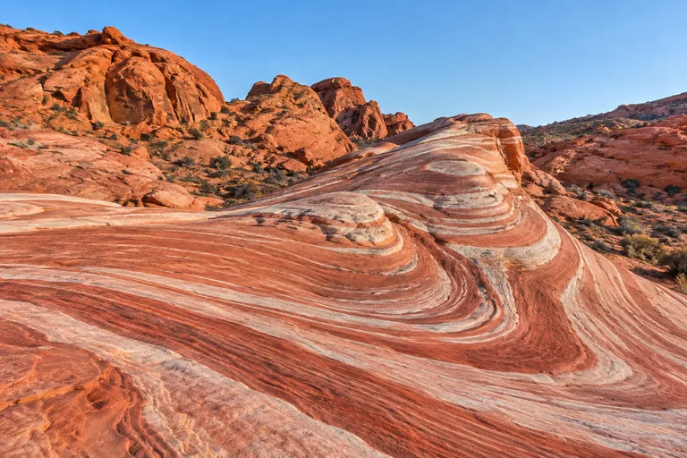
Valley of Fire State Park is Nevada's first state park, a red sandstone desert with ancient rock art and short trails northeast of Las Vegas. It is open daily from sunrise to sunset, all year except for a maintenance closure from December 1 to 14. Many of its best trails, including the Fire Wave and White Domes, close each summer from May 15 to September 30. For families and couples, the best time to visit Valley of Fire State Park is a cool, clear day outside those closures.
This guide covers the trails, the summer closure in the park's words, the drive from Las Vegas, fees, camping and timing. It ends with simple itineraries, hidden gems and insider tips. For the rest of the state, see the Nevada travel guide. Red Rock Canyon, on the other side of Las Vegas, pairs well with this park for a two-day nature weekend, and the plan for that is below.
Valley of Fire State Park at a Glance
| Question | Short answer |
|---|---|
| Where is it? | Southern Nevada, northeast of Las Vegas; the park map puts the West Entrance 12 miles from I-15 by State Route 169 |
| How big is it? | More than 40,000 acres; the park's brochure calls it Nevada's largest state park |
| When did it open? | Easter Sunday 1934, as Nevada's first state park; legal designation followed in 1935 |
| Hours | Sunrise to sunset daily; visitor center 9 a.m. to 4 p.m. daily |
| Annual closure | December 1 to 14 every year, for all visitors, including people on foot |
| Summer trail closure | Many trails closed May 15 to September 30 |
| Entrance fee | $10 per vehicle, $15 for non-Nevada vehicles (November 2026; check the official site) |
| Time needed | Half a day for the main road and short walks; a full day for the longer trails in cool weather |
Visit: Valley of Fire State Park, 29450 Valley of Fire Rd, Overton, NV 89040 | 702-397-2088 | parks.nv.gov/parks/valley-of-fire-state-park
Summer Trail Closures and Desert Heat
Heat shapes every visit here, and the park plans around it. Many trails close every summer. Here is what Nevada State Parks says on its Valley of Fire page today:
- Dates: many of the park's trails "are closed annually" from May 15 to September 30.
- Why: the page gives safety reasons, including medical calls and search and rescue missions.
- Heat warning: "Hiking in high heat is dangerous even on shorter trails."
These are the trails on the park's closure list:
- White Domes Loop
- Fire Wave, Seven Wonders Loop, Pastel Canyon and Pink Canyon
- Pinnacles Loop
- Prospect Trail
- Arrowhead Trail
- Natural Arch Trail, except Arch Rock
- Charlie's Spring
The park's 2025 brochure puts it more broadly. It says, "All trails longer than 1mi/1.6km are closed annually May through September." It gives the reason as "extreme weather resulting in heat-related illnesses and fatalities." When the two sources differ, plan for the stricter one and ask at the visitor center.
How Hot Valley of Fire Gets
The brochure says summer highs often reach 110°F and can exceed 120°F. Winters are mild, from freezing to about 75°F. Average yearly rainfall is below seven inches, from light winter showers and summer thunderstorms. The park's own advice is simple: hiking is not recommended above 85°F (29°C).
Heat and Water Safety
- Start early. Walk in the cool morning hours, and turn back before the day heats up.
- Carry plenty of water. The park asks visitors to conserve water. For nearby Red Rock Canyon, the Bureau of Land Management (BLM) suggests at least two liters per person. It adds a liter per person for each mile of hiking.
- Use the shade. Shaded picnic areas with restrooms sit at Atlatl Rock, Seven Sisters, the Cabins, near the Mouse's Tank Trailhead and at White Domes.
- Know where the phone works. The park map marks only a few spots with possible cell service. In an emergency, call 911.
- Watch the sky. The little rain the park gets comes from light winter showers and summer thunderstorms. The BLM advises staying out of washes when rain is possible.
Valley of Fire from Las Vegas: Getting There
Most visitors drive from Las Vegas. Head north on I-15, then follow State Route 169 to the West Entrance. The park map puts that entrance 12 miles from I-15. The nearest gas on the west side is also about 12 miles out, toward the interstate. The East Entrance is 21 miles from I-15, with the nearest gas about 10 miles north.
Nevada State Parks does not list a mileage from Las Vegas on its park page. Map the drive from the hotel before leaving, and fill the tank in town.
West Entrance Construction in 2026
On July 28, 2026, Nevada State Parks announced a temporary change at the West Entrance. Here is what it said:
- When: starting August 3, 2026, the West Entrance is closed Monday through Thursday.
- Why: crews are building a new entrance lane and an extra fee booth, to cut wait times.
- Weekends: the West Entrance stays open Friday through Sunday on regular hours.
- How long: work is expected to continue through the end of 2026.
- Instead: on weekdays, use the East Entrance, reached from State Route 169 or State Route 167.
Rideshares and Road Conditions
The park warns that Uber and Lyft can leave visitors stranded, because return rides are often unavailable. Drive a private car or book a round trip ahead of time. For road closures on the way, the park points visitors to nvroads.com.
Getting Around Inside the Park
Valley of Fire Road crosses the park between the West and East entrances, with a 35 mph limit. White Domes Road branches north, at 25 mph, toward Rainbow Vista, the Fire Wave and White Domes. A short side road leads to the Fire Canyon and Silica Dome Overlook. Keep these rules in mind:
- Park only in marked areas. The map says, "No parking on side of road."
- Stay on approved routes. Motor vehicles are not allowed on trails.
- Bikes are welcome. The bike-in fee is $2 per bike.
Entrance Fees, Hours and Closures
Valley of Fire charges a daily entrance fee per vehicle. Day use needs no reservation. Fees change, so check the official site before you go. In November 2026 the park listed:
- Vehicle: $10, or $15 for non-Nevada vehicles.
- Bike in: $2 per bike.
- Camping: $20 per vehicle per night for Nevada vehicles, $25 for non-Nevada vehicles, plus $10 for a site with hookups.
Hours are just as simple. The park is open daily from sunrise to sunset, except for campers in the campgrounds. The visitor center is open daily from 9 a.m. to 4 p.m. The office is open Monday through Friday, 9 a.m. to 4 p.m., and closed on state holidays.
The December Maintenance Closure
Each year, Valley of Fire closes from December 1 through December 14. It is closed to everyone, including people on foot. In 2026 the closure runs from Tuesday, December 1, through Monday, December 14, and the park reopens on Tuesday, December 15. Weddings, photo shoots and guided tours are not allowed during the closure. Camping reservations are not available either. The park says high visitation, staffing shortages and extreme summer heat make maintenance hard to keep up with in the busy season.
Valley of Fire Hikes: Trail Table
The park's 2025 map lists 12 named trails. It gives each one a length, but no difficulty rating. Instead it warns, "Trails are over loose sand and/or rough terrain. These hikes often feel longer than listed. Know your limits and be prepared!" The descriptions below come from the park brochure. The last column shows whether the trail is on the park's May 15 to September 30 closure list.
| Trail | Length (park map) | What you see | On the summer closure list? |
|---|---|---|---|
| Balancing Rock | 0.1 mi | A very short walk off Valley of Fire Road | No |
| Petrified Logs Loop | 0.3 mi | Petrified wood from a forested past, near the west side | No |
| Mouse's Tank | 0.7 mi | Petroglyphs and a natural water tank | No |
| Rainbow Vista | 1.0 mi | A walk to a wide canyon view | No |
| White Domes Loop | 1.1 mi | A slot canyon and the remains of a 1960s movie set | Yes |
| Elephant Rock Loop | 1.2 mi | An arch shaped like an elephant; a 0.1-mile direct path also reaches it | No |
| Fire Wave/7 Wonders | 1.8 mi | Colorful formations and small slot canyons | Yes |
| Natural Arch | 2.5 mi | An east side trail near the Cabins | Yes, except Arch Rock |
| Pinnacles Loop | 4.5 mi | A west side loop near Arch Rock | Yes |
| Prospect Trail | 4.6 mi | A long trail between the Atlatl Rock area and White Domes Road | Yes |
| Charlie's Spring | 4.7 mi | An east side trail toward Charlie's Spring | Yes |
| Old Arrowhead Road | 6.8 mi | The route of an old road across the south of the park | Yes (listed as Arrowhead Trail) |
The park suggests asking at the visitor center for hike ideas, which is also the place to confirm which trails are open that day.
Fire Wave and Seven Wonders
The brochure lists the Fire Wave/Seven Wonders Trail at 1.8 miles, with many colorful formations and small slot canyons. Parking for it is on White Domes Road. Plan this one between October 1 and May 14, since it is on the summer closure list. The same closure covers Pastel Canyon and Pink Canyon, which share this part of the park.
White Domes Loop
White Domes Loop is 1.1 miles and sits at the far end of White Domes Road. The park says it passes a slot canyon and the remains of a 1960s movie set. That mix makes it a fun short hike for families with older kids. It is also on the summer closure list.
Mouse's Tank
Mouse's Tank is a 0.7-mile walk off White Domes Road. The park describes petroglyphs along the way and a natural water tank at the end. It is one of the shorter walks not on the summer closure list. Even so, the park's heat warning applies to short trails too.
Rainbow Vista and Elephant Rock
Rainbow Vista is a 1.0-mile walk to a sweeping canyon view on White Domes Road. Elephant Rock, near the East Entrance, is an arch that looks like an elephant. A 0.1-mile direct path reaches it, and a 1.2-mile loop circles the area. Both make easy family stops in the cooler months.
Longer Trails for Cool Days
Prospect Trail (4.6 miles), Pinnacles Loop (4.5 miles), Charlie's Spring (4.7 miles) and Old Arrowhead Road (6.8 miles) are the park's longest routes. All of them are on the summer closure list. Save them for winter and spring, start early, and carry far more water than seems needed.
Best Sights Along Valley of Fire Road
Valley of Fire is easy to enjoy from the car, with short walks from each parking area. These stops come from the park's map and brochure, roughly from west to east:
- Beehives Formations: near the West Entrance and the group camping area.
- Atlatl Rock: centuries-old rock writings that show the atlatl, a spear-throwing tool. It has shaded picnic tables and restrooms.
- Arch Rock: beside the campground of the same name, and excluded from the Natural Arch summer closure.
- Petrified Logs: a short loop past petrified wood.
- Balancing Rock: a 0.1-mile walk from the road.
- Seven Sisters: a picnic area with shade and restrooms.
- The Cabins: cabins built by the Civilian Conservation Corps in the 1930s, with a shaded picnic area.
- Elephant Rock: the elephant-shaped arch near the East Entrance.
Two side roads add more. White Domes Road leads north to Mouse's Tank, Rainbow Vista, the Fire Wave and White Domes. Fire Canyon Road leads to the Fire Canyon and Silica Dome Overlook. The park notes it was a filming location for Star Trek: Generations (1994).
The Visitor Center
Start at the visitor center if the timing works. It has exhibits on the park's geology, ecology, prehistory and history, and the park lists a gift shop. Rangers give programs and special talks for groups on request. Pets are not allowed inside, except service animals. The park also offers Wi-Fi with paid plans.
Best Time to Visit Valley of Fire
The best time to visit Valley of Fire is between October 1 and May 14, on a cool day. Every trail is open then, except during the December 1 to 14 closure. Summer is still possible for a short drive, but most of the best hikes are closed.
| Season | Weather (park brochure) | What is open |
|---|---|---|
| Winter (December to February) | Mild, from freezing to about 75°F | Whole park closed December 1 to 14; all trails open from December 15 |
| Spring (March to mid-May) | No figures given; check the forecast, since hiking is not recommended above 85°F | All trails open until May 14 |
| Summer (mid-May to September) | Highs often reach 110°F and can exceed 120°F | Many trails closed May 15 to September 30; roads and short stops open |
| Fall (October and November) | No figures given; the same 85°F advice applies | Closed trails reopen after September 30 |
Light matters here too. The park's history says the name came from an AAA official who drove through at sunset in the 1920s and thought the valley looked on fire. Day use ends at sunset, so a campsite is the way to stay for the evening glow and the stars.
Through the end of 2026, the day of the week matters as well. The West Entrance is closed Monday through Thursday, so a weekday visit means a longer approach through the East Entrance. A Friday, Saturday or Sunday visit keeps the shorter west side route.
Camping at Valley of Fire
Valley of Fire has two campgrounds, Atlatl Rock and Arch Rock, near the west side of the park. The park's web page lists 72 units in total, and its 2025 brochure lists 73 sites. Here is what the park says about them:
- At each site: potable water, a fire pit and a shaded picnic table.
- Shared: restrooms, showers and a dump station.
- Hookups: some RV sites have power and water hookups, for $10 more per night.
- Reservations: all sites are by reservation on ReserveNevada (the park's page links to it), up to 11 months ahead and at least 72 hours ahead.
- Group sites: three group sites, each for up to 45 people, by reservation only.
- Limits: 14 days in any 30-day period. State park campsites hold up to two vehicles and eight people.
Campfires are allowed only in the fire pits and grills, and fire limits may apply at times. If the campgrounds are full, the brochure notes dispersed camping on public lands outside the park. Camping inside the park is allowed only in the marked sites.
Valley of Fire History and Geology
The red rock is Aztec sandstone from the Jurassic period. The brochure says these formations were sand dunes more than 150 million years ago, in the age of the dinosaurs. Gray limestone remains from a time when a sea covered the land. Petrified wood shows that forests once grew here too. Wind and water still shape the rock today.
People have used this land for thousands of years. The park's history page says people reached southern Nevada as early as about 11,000 years ago. The clearest signs are petroglyphs carved by the Basketmaker culture about 2,500 years ago. An early Pueblo culture followed. The same page notes Paiutes living in the area in 1865.
Modern history moves fast from there:
- 1912: a rough road through the area became part of the Arrowhead Trail between Salt Lake City and Los Angeles.
- 1920s: about 8,500 acres of federal land were given to Nevada, and the name Valley of Fire caught on.
- 1933: the Civilian Conservation Corps built the first facilities and campgrounds, including cabins.
- 1934: the park opened on Easter Sunday as Nevada's first state park.
- 1935: the Nevada Legislature gave it legal designation.
Today the park covers more than 40,000 acres, close to five times the size of that first gift of land.
Wildlife and Desert Plants
The park looks empty at midday, but plenty lives here. The brochure notes these residents:
- Desert bighorn sheep: they drink when water is available, up to five gallons at a time.
- Desert tortoises and Gila monsters: they spend most of their lives underground.
- Kit foxes and jackrabbits: mostly active at night.
- Rattlesnakes and chuckwallas: often seen basking in the sun.
- Gambel's quail: a body temperature of about 107°F helps them shed heat.
Plants such as brittlebush and desert holly are pale, which helps them reflect sunlight. In some spots a dark living crust of tiny organisms covers the sand. It feeds nearby plants and slows erosion, so step around it.
Valley of Fire Itineraries
Half a Day from Las Vegas
- Morning: leave Las Vegas early with a full tank, plenty of water and snacks.
- West side: stop at the Beehives Formations, Atlatl Rock and the Petrified Logs Loop.
- Center: stop at the visitor center for maps and trail news, then drive White Domes Road to Mouse's Tank and Rainbow Vista.
- Overlook: take Fire Canyon Road to the Fire Canyon and Silica Dome Overlook.
- East side: walk the short path to Elephant Rock, then head back to Las Vegas.
On a Monday through Thursday in 2026, run this plan in reverse. Enter by the East Entrance, start at Elephant Rock and work west.
A Full Day in the Cool Season
- Early morning: hike the Fire Wave and Seven Wonders area while it is still cool.
- Late morning: walk White Domes Loop and its slot canyon.
- Midday: picnic in the shade at the Cabins or Seven Sisters.
- Afternoon: Mouse's Tank for petroglyphs, then Atlatl Rock.
- Late afternoon: Rainbow Vista or the Silica Dome Overlook as the rock starts to glow. Day use ends at sunset.
A Summer Visit
Between May 15 and September 30, keep it short. Arrive at sunrise and stick to roadside stops and trails not on the closure list. Petrified Logs, Balancing Rock, Mouse's Tank, Rainbow Vista and Elephant Rock fit that plan. Remember the park's advice that hiking is not recommended above 85°F. Leave before the worst heat of the day.
A Two-Day Las Vegas Nature Weekend
- Day 1, Valley of Fire: follow the full day plan above, or camp at Atlatl Rock or Arch Rock.
- Day 2, Red Rock Canyon: drive the 13-mile scenic loop, 17 miles west of the Las Vegas Strip, and take a short hike. The BLM requires a timed entry reservation for that drive from October 1 to May 31, for entry between 8 a.m. and 5 p.m.
Hidden Gems at Valley of Fire
Most visitors head straight for the Fire Wave. These quieter spots reward a little extra time:
- The Cabins: 1930s shelters built by the Civilian Conservation Corps, with a shaded picnic area.
- The Petrified Logs Loop: a 0.3-mile walk to wood that turned to stone long ago.
- The Silica Dome Overlook: a wide view that also appeared in Star Trek: Generations.
- The White Domes movie set: remains of a 1960s set along the loop, open outside summer.
- Arch Rock: left out of the Natural Arch summer closure, beside its campground.
- The east side monuments: the map marks Clark's Memorial, Lone Rock and a monument to Nevada's first state park.
- Night skies: campers have the park after sunset, when day visitors must leave.
Insider Tips for Visiting Valley of Fire
- Check the calendar twice. Avoid December 1 to 14, and plan big hikes outside May 15 to September 30.
- Mind the West Entrance schedule. Through the end of 2026 it is closed Monday through Thursday, so use the East Entrance on weekdays.
- Fill up first. The nearest gas is about 12 miles from the West Entrance and 10 miles north of the East Entrance.
- Skip the rideshare plan. The park warns that return rides are often unavailable.
- Download the map. Cell service is spotty, so save the park's map and brochure before leaving town.
- Watch the thermometer. The park does not recommend hiking above 85°F.
- Book campsites early. Sites open up to 11 months ahead and close to booking 72 hours out.
- Leave the drone at home. Drones and remote-controlled aircraft are not allowed.
- Drive slowly. The limit is 35 mph on Valley of Fire Road and 25 mph on White Domes Road.
- Plan school and group trips a month out. The park asks groups to contact it 30 days before a field trip.
Park Rules to Know
The park's rules protect fragile rock and very old rock art. These are the ones most visitors need:
- Petroglyphs and arches: do not climb on them, and do not touch the petroglyphs.
- Rocks and artifacts: removing or damaging rocks, plants, fossils or artifacts is illegal. So is carving or writing on rock.
- Wildlife: do not feed the animals.
- Pets: welcome on a leash up to six feet long, but not in the visitor center.
- Climbing: only in set areas; ask at the visitor center. Chalk and anything placed in the rock are not allowed.
- Commercial photos and filming: a permit is required.
Frequently Asked Questions About Valley of Fire State Park
Where is Valley of Fire State Park?
Valley of Fire State Park is in southern Nevada, northeast of Las Vegas, at 29450 Valley of Fire Road, Overton. It covers more than 40,000 acres and opened in 1934 as Nevada's first state park. The park map puts the West Entrance 12 miles from I-15 by State Route 169.
How do you get to Valley of Fire from Las Vegas?
Drive north on I-15, then follow State Route 169 to the West Entrance. From August 3, 2026 through the end of 2026, that entrance is closed Monday through Thursday for construction. On those days, use the East Entrance from State Route 169 or 167. Do not count on a rideshare for the trip home.
Are Valley of Fire trails closed in summer?
Yes. Nevada State Parks says many trails close every year from May 15 to September 30. The list includes White Domes, the Fire Wave and Seven Wonders area, Pinnacles, Prospect, Arrowhead, Natural Arch (except Arch Rock) and Charlie's Spring. The park's 2025 brochure says all trails longer than 1 mile close May through September.
What is the best time to visit Valley of Fire?
Visit between October 1 and May 14, when the trails are open, but skip December 1 to 14, when the whole park closes. Winters range from freezing to 75 degrees. The park does not recommend hiking above 85 degrees, and summer highs often reach 110 degrees.
What are the best hikes in Valley of Fire?
The park brochure singles out the Fire Wave and Seven Wonders Trail (1.8 miles), White Domes Loop (1.1 miles), Mouse's Tank (0.7 miles), Rainbow Vista (1.0 mile) and Elephant Rock Loop (1.2 miles). The first two are closed May 15 to September 30. Trails cross loose sand and often feel longer than listed.
How much does it cost to enter Valley of Fire?
In November 2026 the park listed $10 per vehicle, or $15 for vehicles not registered in Nevada, and $2 per bike. Camping costs extra. Fees change, so check the official site before you go.
Is Valley of Fire closed in December?
Yes, for two weeks. Valley of Fire closes to all visitors, including people on foot, from December 1 through December 14 each year for maintenance. In 2026 it reopens on Tuesday, December 15. Camping reservations are not available during the closure.
Can you camp at Valley of Fire State Park?
Yes. Atlatl Rock and Arch Rock campgrounds have sites with water, fire pits and picnic tables, plus showers, a dump station and some hookups. All sites are by reservation on ReserveNevada, up to 11 months ahead and at least 72 hours ahead. The stay limit is 14 days in 30.
Are dogs allowed at Valley of Fire?
Yes. Pets are welcome on a leash no longer than six feet. Only service animals are allowed in the visitor center. Plan walks for the cool part of the day.
Should you visit Valley of Fire or Red Rock Canyon?
Both make easy trips from Las Vegas, and they are different. Valley of Fire is a state park northeast of the city with petroglyphs and slot canyons. Red Rock Canyon is a federal conservation area 17 miles west of the Strip, with a 13-mile scenic drive and timed entry from October to May.
Ready to plan the rest of the trip? Start with the Nevada travel guide for Las Vegas, Lake Tahoe, Hoover Dam and the long desert drives between them.
Planning your next U.S. getaway? Explore more destination guides, road trips, and travel tips at Vacation Getaways US. Have a question or a spot we should cover? Email us at [email protected].