
How To Plan An Amazing Weekend Getaway: Tips For Your Next Trip
May 21, 2021
Simple steps for planning a short trip, from picking dates to booking a place to stay.
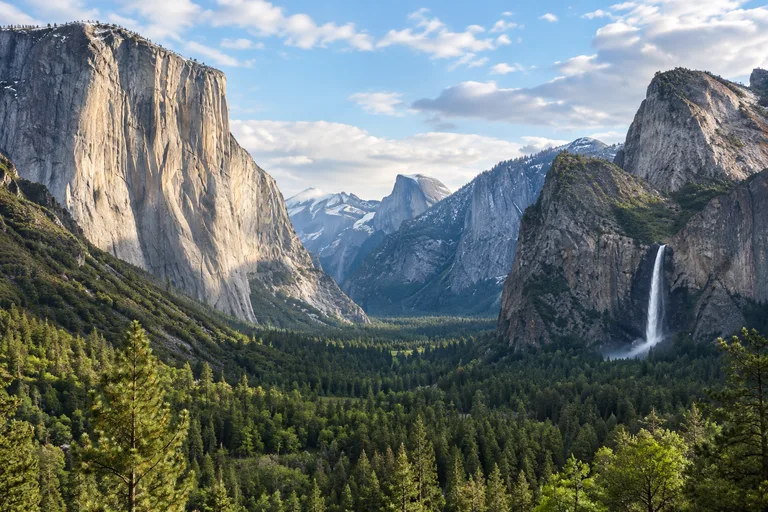
This Yosemite travel guide starts with the short answer. Yosemite National Park covers nearly 1,200 square miles of California's Sierra Nevada, and most first visits center on Yosemite Valley, where El Capitan, Half Dome and Yosemite Falls all rise above the same valley floor. Plan two to three days, come in May or June for the waterfalls, and arrive before 8 am, because valley parking is usually full after that. No entry reservation was needed in 2026.
The rest of this guide covers the best time to visit Yosemite, the drive from San Francisco and other cities, Yosemite Valley things to do, the best hikes, where to stay, and a plan for one, two or three days. Yosemite is one stop in the wider California travel guide, and it pairs well with a few days on the coast or at Lake Tahoe. Families, couples and solo travelers all find a trip that fits here, from flat meadow walks to all-day climbs.
These are the facts most travelers need before they book. Every figure comes from the National Park Service pages listed in the sections below.
| Question | Short answer |
|---|---|
| Where is it? | Central California, in the Sierra Nevada. Yosemite Valley is 195 miles from San Francisco and 94 miles from Fresno. |
| How big is it? | Nearly 1,200 square miles. |
| Is it open all year? | Yes. Yosemite Valley and Wawona can be reached by car all year. Two high roads close for snow. |
| Entry reservation? | Not required in 2026. Check the park site for the current year. |
| Entrance fee? | $35 per private vehicle for seven days, as listed in November 2026. Cards only, no cash. |
| Best months? | May and June for waterfalls. July to October for the high country. Winter for quiet and snow. |
| How long to stay? | Two to three days for a first visit. |
| Park phone | 209/372-0200 |
Contact: Yosemite National Park, Visitor Information Office, PO Box 577, Yosemite, CA 95389. Phone: 209/372-0200. Web: nps.gov/yose.
No reservation was needed to drive into Yosemite in 2026. The park's reservation page says Yosemite "will no longer use a timed reservation system in 2026" and manages traffic and parking at busy times instead. The page had no rules for 2027 when this guide was written, so check the official reservations page before any trip. Entry rules have differed from one year to the next.
Entrance fees are paid at the gate. The park's fee page listed these in November 2026:
The park does not accept cash. Bring a credit or debit card or a phone that can pay. Fees change, so check the official site for the current amounts.
The best time to visit Yosemite is May and June for most travelers. Snowmelt fills the waterfalls, Yosemite Valley is green, and the road to Glacier Point usually opens in May. The trade-off is that the highest trails are still snowy and the Tioga Road may not open until late May or June. Each season gives a different park, so the right month depends on the trip.
| Months | Weather | What is open | Good for |
|---|---|---|---|
| November to February | Cold and wet, with most precipitation as snow | Yosemite Valley and Wawona by car. Tioga Road and Glacier Point closed. Road plowed to Badger Pass from mid-December. | Quiet valley walks, skiing, Horsetail Fall in February |
| March and April | Warm sunny days can turn cold and stormy | Valley, Wawona and Hetch Hetchy may be free of snow. Mariposa Grove Road usually opens in April. | Rising waterfalls, low trails, fewer people |
| May and June | Hard to predict, depends on the winter snow | Glacier Point Road usually opens in May. Tioga Road usually opens in late May or June. | Peak waterfalls, valley hikes |
| July to October | Warm and dry. Afternoon thunderstorms are common. | The whole park, until the first big snow, which is typical in October | Tuolumne Meadows, long hikes, Half Dome |
Spring is the season for water. The park says the snow line sits near 5,000 feet in March and 6,000 feet in April, so Yosemite Valley, Wawona and Hetch Hetchy, all around 4,000 feet, may be clear while the high country stays buried. Streams and rivers fill with runoff, and most of the famous falls peak in May. Weather swings fast in these months, so pack for both sun and a cold storm.
From July through October the park is warm and dry. Yosemite gets less than five percent of its yearly precipitation in summer. Daytime highs in Yosemite Valley sometimes reach 100°F, while Tuolumne Meadows, at 8,600 feet, usually stays in the 70s by day and near freezing at night. Smaller creeks may dry up late in summer, and Yosemite Falls often stops flowing after July. The park also notes that one to three weeks of unhealthy smoky air are common from August through September.
September and October keep the dry weather and lose much of the crowd. The high roads stay open until the first significant snow, which is typical in October. Overnight parking is not allowed on the Tioga Road and Glacier Point Road from October 15, and the Half Dome cables usually come down the day after the second Monday in October. Waterfalls are at their lowest, so plan fall trips around views, hikes and the meadows.
Winter is snowy and cold, though sunny, chilly days are common. The park lists typical winter temperatures in Yosemite Valley and Wawona between 28°F and 53°F. More than 70 percent of the year's precipitation falls from November through March. The valley stays open, the crowds are gone, and the cliffs wear snow. Tire chains are often required, and the next sections explain what closes.
Most visitors drive, and the route depends on the starting city and the season. Highway 140 through Merced and Mariposa, Highway 120 through Manteca and Groveland, and Highway 41 through Fresno and Oakhurst are the year-round routes to Yosemite Valley, though a storm can close one for a time. The Tioga Road, the eastern way in from Lee Vining, is open only from about late May or June through October or November. The table uses the distances and times on the park's driving directions page, which assume good conditions and no stops.
| From | Route | Distance to Yosemite Valley | Drive time |
|---|---|---|---|
| San Francisco | Highway 120 | 195 miles | 4 hours |
| San Francisco | Highway 140 | 211 miles | 4 hours |
| Oakland | Highway 120 | 186 miles | 3 hours 45 minutes |
| San Jose | Highway 120 | 182 miles | 4 hours |
| Sacramento | Highway 140 | 195 miles | 4 hours |
| Fresno | Highway 41 | 94 miles | 2 hours 15 minutes |
| Los Angeles | Highway 41 | 313 miles | 6 hours |
| San Diego | Highway 41 | 441 miles | 8 hours |
| Reno | Tioga Road, summer and fall only | 218 miles | 4 hours |
| Las Vegas | Tioga Road, summer and fall only | 399 miles | 8 hours |
Yosemite from San Francisco is a four hour drive each way, so it works far better as an overnight trip than as a day trip. The park's directions head east on Interstate 580 and Interstate 205, then follow Highway 120 through Manteca or Highway 140 through Merced. Highway 120 is the shorter route at 195 miles. Highway 140 is 211 miles and follows the Merced River canyon into the park.
A day trip is possible with a very early start, but it means eight hours in the car for a few hours in the valley. Two nights give a full day in Yosemite Valley and a second day for Glacier Point or the sequoias. Leave the Bay Area early enough to pass the entrance gate before 8 am, or plan to arrive in the late afternoon when day visitors are leaving.
Yosemite can be reached by public transportation all year. The park's public transportation page lists these options:
YARTS buses charge a fare. The park notes that luggage storage is not available in Yosemite, so travel light on a car-free trip.
Once a car is parked in Yosemite Valley, leave it there. The park says plainly that drivers who give up a space may not find another. Two free shuttles cover the valley from 7 am to 10 pm. The Valleywide Shuttle serves every stop, with buses every 12 to 22 minutes. The East Valley Shuttle links Yosemite Village, Curry Village, the Pines campgrounds and the eastern trailheads every 8 to 12 minutes.
A few practical points save trouble:
Yosemite Valley holds most of the park's famous sights, and many of the best Yosemite Valley things to do take less than an hour. El Capitan rises over 3,000 feet above El Capitan Meadow. Half Dome closes the east end of the valley. The Merced River winds between meadows on the flat valley floor. A first day here can be spent almost entirely on short walks and roadside views.
The park's viewpoints page describes each of these stops:
Yosemite's waterfalls are a spring show. Most peak in May, and several are dry by late summer. The table uses the heights and seasons on the park's waterfalls page.
| Waterfall | Height | Flows | How to see it |
|---|---|---|---|
| Yosemite Falls | 2,425 feet | About November through July, peak in May | From Yosemite Village and Yosemite Valley Lodge, or the one mile loop to the base of the lower fall |
| Bridalveil Fall | 620 feet | All year, peak in May | From Tunnel View, or a short trail from its signed parking lot |
| Vernal Fall | 317 feet | All year, peak in late May or June | From Glacier Point at a distance, or the Mist Trail |
| Nevada Fall | 594 feet | All year, peak in late May or June | From Glacier Point at a distance, or the trail beyond Vernal Fall |
| Ribbon Fall | 1,612 feet | About March through June | From turnouts on the road into the valley, just past the Bridalveil Fall turn |
| Sentinel Falls | About 2,000 feet | About March through June | From Southside Drive near Sentinel Beach Picnic Area |
| Horsetail Fall | 1,000 feet | About December through April | From the El Capitan picnic area on Northside Drive |
Three short walks give the most reward for the least effort, and all suit families with young children. The distances come from the park's list of valley day hikes.
The Yosemite Exploration Center, once called the Valley Visitor Center, is open all year with exhibits on geology, plants and animals, history and rock climbing. Next door, the Yosemite Museum covers the cultural history of the park's associated tribes from 1850 to the present. Both make a good first stop or a rainy day plan. The park also lists biking and fishing from spring to fall, water activities in summer, ice skating in winter, and tours and ranger programs all year.
The best valley hikes climb out of the crowds within a mile or two. The table lists the park's own figures. Distances are round trip unless noted.
| Trail | Distance | Climb | Park rating |
|---|---|---|---|
| Vernal Fall Footbridge | 1.6 miles | 400 feet | Moderate |
| Top of Vernal Fall by the Mist Trail | 2.4 miles | 1,000 feet | Strenuous |
| Top of Nevada Fall by the Mist Trail | 5.4 miles | 2,000 feet | Strenuous |
| Yosemite Falls Trail | 2 miles for the shorter option, 7.2 miles to the top | 1,000 feet or 2,700 feet | Moderate to strenuous |
| Valley Loop Trail | 6.5 miles for the half loop, 13 miles for the full loop | Mostly flat | Moderate |
| Four Mile Trail | 4.8 miles one way | 3,200 feet | Strenuous |
| Half Dome | 14 to 16.4 miles | 4,800 feet | Strenuous |
The Mist Trail is the valley's signature hike. It starts at Happy Isles, shuttle stop 16, and reaches the Vernal Fall Footbridge in about an hour to an hour and a half round trip. Beyond the bridge, a granite stairway of more than 600 steps climbs beside the fall. The park allows three hours for the round trip to the top of Vernal Fall and five to six hours to the top of Nevada Fall.
Drinking water is available only at the trailhead and, from May to October, at the footbridge. The park suggests one quart per person to the footbridge, two to the top of Vernal Fall and three to four to the top of Nevada Fall. Stay on the trail and out of the river. Swimming at Emerald Pool and the Silver Apron above the fall is illegal because of the current. In winter the lower Mist Trail closes for falling ice and rock, so check the trail page first.
Half Dome is a long, hard day of 14 to 16.4 miles with 4,800 feet of climbing, and the last stretch goes up steel cables. A permit is required every day the cables are up, normally from the Friday before Memorial Day through the day after the second Monday in October. The park allows up to 300 hikers a day beyond the base of the subdome, about 225 day hikers and 75 backpackers.
Yosemite Valley is only a small part of the park. Four other areas are worth a half day or more each, and three of them depend on roads that close for snow.
Glacier Point stands 3,214 feet above Curry Village, with a view over Yosemite Valley, Half Dome, Yosemite Falls and the high country. It is about 30 miles and one hour by car from the valley or from Wawona. The road is open to cars from about late May through October or November. Washburn Point, just to the south, gives a more direct look at Vernal Fall and Nevada Fall. Arrive by 9 am in summer, because a full lot can mean delays of up to two hours.
The Mariposa Grove, near the South Entrance, holds more than 500 mature giant sequoias, including the Grizzly Giant, which the park puts at 3,000 years old. Visitors park at the Mariposa Grove Welcome Plaza, which has about 300 spaces, and ride a free shuttle that runs about every 15 minutes in season. Only vehicles with a disability placard may drive the grove road.
Named trees in the grove include the Fallen Monarch, the Bachelor and Three Graces, the Grizzly Giant and the California Tunnel Tree. There is no shuttle from December 1 through at least April 15. In those months the grove is reached by a two mile walk each way, on the Washburn Trail or the closed road, with about 500 feet of climbing.
The Tioga Road runs 47 miles from Crane Flat to Tioga Pass through the park's high country. Tuolumne Meadows sits at about 8,600 feet, cool in summer and wide open. The road is open from about late May or June through October or November.
Wawona, in the south of the park near the Mariposa Grove, is open by car all year. Chilnualna Falls, about 2,200 feet high, hides above it on a steep trail and cannot be seen from any road. Hetch Hetchy is a reservoir valley at 3,900 feet above sea level with one of the longest hiking seasons in the park. Its road is open from sunrise to sunset. Its details are in the hidden gems section below.
Winter Yosemite is a real trip, not a consolation prize. Yosemite Valley and Wawona stay open by car, and some valley trails are often usable. The park's winter page and current conditions page give the details. In mid-November 2026 the Tioga Road and Glacier Point Road had already closed for the season.
Before any winter drive, read the current conditions page. Roads can close for snow on short notice. In mid-November 2026, for example, the Big Oak Flat Road was closed for a time because of snow.
Staying inside the park saves hours of driving and solves the parking problem, because guests park at their lodge or campground. Lodging in the park is run by Yosemite Hospitality, and reservations open 366 days ahead. The park's lodging page lists these options:
Yosemite has 13 campgrounds, and reservations are needed for all of them from about April through October. The park's campground page explains the release dates. Most valley sites are released five months ahead on the 15th of the month, and several high country campgrounds are released two weeks ahead. Upper Pines, Camp 4, Wawona and Hodgdon Meadow are listed as open all year. Camp 4 is for tents only. Nightly fees ranged from $24 to $36 per site in 2026, and Camp 4 was $10 per person. Popular sites fill fast, so be ready at the release time. Travelers who like a roof can also look at cabin camping options outside the park.
When the park is full, look along the three western highways. Mariposa, Midpines and El Portal line Highway 140. Groveland and Buck Meadows sit on Highway 120. Oakhurst and Fish Camp are on Highway 41 near the South Entrance and the Mariposa Grove. Lee Vining, June Lake and Mammoth Lakes serve the east side when the Tioga Road is open. Allow for the drive in and the 8 am parking deadline when choosing a town.
These quieter spots reward travelers who look past the main stops. Each one is named on a National Park Service page.
Two to three days suit most first visits. One day shows the valley. Each added day opens another part of the park. These plans assume a spring to fall visit with the high roads open.
Spend day one as above. On day two, drive to Glacier Point early, stop at Washburn Point, and then continue south to the Mariposa Grove for the Grizzly Giant Loop. In winter and early spring, swap Glacier Point for a longer valley hike, such as the Mirror Lake loop.
Add a big hike or the high country. Strong hikers can take the Mist Trail to the top of Nevada Fall. In summer and early fall, the other choice is a day on the Tioga Road, with stops at Olmsted Point, Tenaya Lake and Tuolumne Meadows. Travelers heading on to Nevada can leave the park over Tioga Pass when the road is open.
Yosemite is home to hundreds of American black bears, and the food rules carry the force of federal law. The park counts every scented item as food, including drinks, soap, toiletries, trash and empty ice chests. Follow the park's bear rules:
Breaking the rules can bring a fine of up to $5,000 and the loss of a campsite or room. Afternoon thunderstorms in summer and icy trails in winter are the other main hazards, so start hikes early and turn around when the weather changes.
May 21, 2021
Simple steps for planning a short trip, from picking dates to booking a place to stay.

May 21, 2021
Ways to compare fares and find flight deals before booking a trip to California.

April 28, 2021
A checklist of what to pack for a two or three day trip in any season.
May and June are the best time to visit Yosemite for waterfalls, because most of the falls peak with the snowmelt in May. July through October brings warm, dry weather and open high country roads. November through April is the quiet season, with snow, tire chain rules and two main roads closed.
No reservation was needed to drive into Yosemite in 2026. The National Park Service says the park no longer uses a timed reservation system in 2026 and manages traffic and parking at busy times instead. Rules can change from year to year, so check the official park site before a trip.
The park listed these entrance fees in November 2026: 35 dollars per private vehicle, 30 dollars per motorcycle and 20 dollars per person on foot or bicycle, each good for seven days. Visitors who are not United States residents and are 16 or older pay 100 dollars more per person unless they hold an annual pass. The park does not accept cash.
Yosemite Valley is 195 miles from San Francisco by Highway 120 and 211 miles by Highway 140. The National Park Service lists the drive at about four hours in good conditions with no stops.
Two to three days suit most first visits. One day covers Yosemite Valley. A second day adds Glacier Point or the Mariposa Grove of Giant Sequoias. A third day leaves time for a long hike or the Tioga Road and Tuolumne Meadows in summer.
The top Yosemite Valley things to do are the Tunnel View and Valley View overlooks, the one mile loop to Lower Yosemite Fall, the short walk to Bridalveil Fall, the Cook's Meadow Loop, the Mist Trail to Vernal Fall and the Yosemite Exploration Center and Yosemite Museum.
Most Yosemite waterfalls peak in May, and Vernal Fall and Nevada Fall peak in late May or June. Yosemite Falls flows from about November through July and is often dry in late summer. Bridalveil Fall, Vernal Fall and Nevada Fall flow all year.
Yes. Yosemite Valley and Wawona can be reached by car all year. The Tioga Road and the road to Glacier Point close for snow, usually in November, and tire chains are often required on park roads. Winter visitors find snow on the cliffs, skiing at Badger Pass and far fewer people.
Yes. A permit is required seven days a week when the Half Dome cables are up, normally from the Friday before Memorial Day through the day after the second Monday in October. The preseason lottery runs March 1 through March 31, and a daily lottery opens two days before each hiking date.
Yes. Amtrak and Greyhound connect to Merced, and YARTS buses run from Merced to Yosemite Valley all year on Highway 140. Inside Yosemite Valley, free shuttles run from 7 am to 10 pm and reach the main trailheads, lodges and viewpoints.
Planning your next U.S. getaway? Explore more destination guides, road trips, and travel tips at Vacation Getaways US. Have a question or a spot we should cover? Email us at [email protected].